Address Advisory
The purpose of an address advisory is to provide Dispatchers and Responders with information that will help us more effectively assist YOU, the caller.
Any information provided will be entered into our Computer Aided Dispatch System, allowing Dispatchers to instantly know any special information that would assist responders if ever called to your residence. The information you provide will be kept confidential on a secure computer system, only accessible by emergency personnel.
Examples of what information could assist responders:
- Any medical conditions or disabilities you or a family member has.
-
Any aggressive pets that may pose a problem for responders getting to you in an emergency.
-
Service dogs or equipment.
- Name and phone number of a neighbor or family member that has a key to your residence.
- Location of bedrooms within the residence for quick access by firefighters in a fire.
- Any special instructions on how to find the residence, back a long lane, ect.
Information will only be considered accurate for one (1) year from the date of submission. Please resubmit after the year is up, or if any information changes.
To complete the Address Advisory Form click here.
Pay Parking Tickets
If your ticket looks like the example below, click the image below.
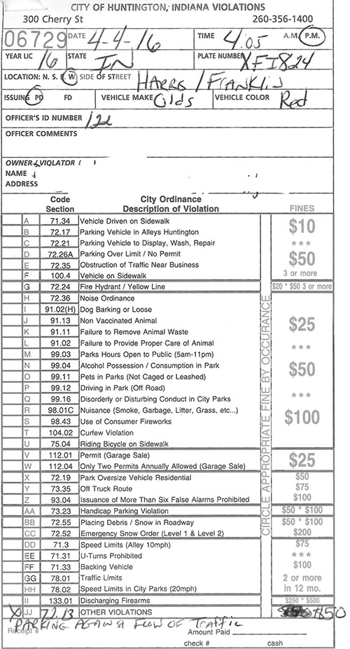
For all other tickets, click on the image below:

NOTE: When entering ticket number use numbers only – NO letters or leading zeros.
To pay parking tickets by phone, call: (855) 288-1564.
To pay parking tickets by mail, send to:
City Clerk-Treasurer's Office
300 Cherry Street
Huntington, IN 46750
Questions? Call (260) 356-1400 Ext. 2019 for assistance.
Summer Parks & Recreation for Kids (SPARK)

2024 SPARK registration open now!
Summer 2024 camp dates are June 3 through July 12.
Ages: 4 to 14
Cost: $25 per child
Locations: Drover Park and Memorial Park
Sign Up Online: bit.ly/3TFh7bj
| Important Information |
|
Facility Rentals
The deposit and rental agreements are required at time of booking. Please call (260) 358-2323 ext. 2502 or visit our office at 634 Webster St. to rent a pavilion or the gardens. A credit or debit card is required.
Park Weddings
Sunken Gardens: $400 + tax $70 deposit
Waltonian Gardens (located at north end of Memorial Park): $400 + tax $70 Deposit
Pavilion Rentals
Large Pavilions ($80 per day + tax):
- Memorial Park
- Elmwood Park
Small Pavilions ($40 per day + tax):
- Memorial Park
- Evergreen Park
- Yeoman Park
- General Slack Park
- Elmwood Park
- Laurie Park
Outdoor Stage
Rental: $20 per day + tax
Location: Hier's Park, 547 S. Briant St.
Softball Fields
- Yeoman Park
- Hier's Park
- Elmwood Park
| Completed rental agreement forms (see the "Forms" tab below) can be emailed to megan.thompson@huntington.in.us or dropped off at City Services, 634 Webster St. |
Snow Removal
During a snow event, clearing main roads is a priority. Secondary roads, subdivisions and alleys are addressed after main roads have been cleared.
Anti-icing and De-icing
- The Street Department may apply an anti-icing salt/abrasive mixture to intersections, bridges and high-traffic areas when a snow or ice event is expected.
- De-icing begins after snow or ice has begun accumulating on road surfaces.
Snow Plowing
Plowing typically begins when an inch or more of snow has accumulated on the road.
- Citizens are asked to please remove vehicles from streets to allow for curb-to-curb plowing.
- Residents are required to remove snow and ice from sidewalks within 24 hours of each weather occurrence.
- It is recommended to allow the snow plow to pass before clearing your sidewalk.
- If you see a snow plow while driving, please stay back several car lengths and, if you must pass, do so with extra caution.
Traffic Control
- Traffic signals.
- Street signs.
-
Road closures.
-
Curb and street markings.
Fall Leaf Collection
Posted Thursday, December 14, 2023.
Trash & Recycling


City of Huntington Trash & Curbside Recycling Program
- Place containers in front of residence (no alley pick up).
- Containers must be out by 6 a.m. and pulled back to residence by 7 p.m.
- All TRASH must be bagged. No loose trash in container.
- All RECYCLING items must be loose or placed in paper bags. Please do NOT use plastic bags.
- Wheels must face house.
- Lids must be completely closed.
- Only carts issued by GFL Environmental are allowed.
- Do not place oil, paint, solvents, construction material (dry wall, shingles, lathe and plaster), tires, batteries, propane tanks, TV's, computer monitors, heavy metal parts, dirt, rock or concrete in container.
Missed Pickup or Damaged Bin?
- Please call (260) 356-4720 for assistance or contact us through the Huntington Connect portal.
Recycling Drop-Off Locations
In addition to the city's curbside recycling program, the following materials are accepted at the Hazardous Materials Facility, 517 S. 300 W., and across from Memorial Park, behind the city park shop on West Park Drive:
- Plastic: #1 through #5 plastic bottles, jugs and containers.
- Glass: Only clear, brown and green food and beverage glass bottles and jars.
- Paper: Newspapers, magazines, junk mail, soap and cereal boxes, catalogs, phones books, school and office papers, paper grocery sacks and other cardboard boxes.
- Metal: Aluminum beverages cans, steel/tin food cans, empty aerosol cans, empty and dry paint cans.
Are You Looking For?
- Orange Sticker Program - Schedule disposal of large items such as furniture, mattresses, bathroom fixtures and more.
- Brown Bag Program - Schedule disposal of yard waste including grass clippings, hedge trimmings, leaves, small twigs and branches.
Orange Sticker Program
Residents of Huntington may purchase an Orange Sticker for $5 to schedule disposal of large items such as furniture, mattresses, bathroom fixtures and more. One sticker is required for each item. After purchasing an Orange Sticker and scheduling pickup, attach the sticker to your item and place it at the curb in front of your home for collection.
Orange Stickers may be purchased at:
- City Services, 634 Webster St. (credit/debit only).
- Clerk-Treasurer's Office, 300 Cherry St., 2nd floor (credit/debit, cash or check).
Please call the Street Department at (260) 356-4720 or email street@huntington.in.us with any questions or if you are unsure whether an item is eligible for the Orange Sticker Program.
Prohibited Items
Prohibited items include but are not limited to:
- Oil.
- Paint.
- Solvents.
- Tires.
- Batteries.
- Propane tanks.
- TVs.
- Computer monitors.
Huntington residents may take the items listed above to the Solid Waste District Hazardous Waste Area, without charge, on Wednesdays from 7 a.m. until 3 p.m., and the first and third Saturday of each month from 8 to 11:30 a.m.
Permits and Licenses
- Garage sale permit information:
$3. Limit two per year at the same address. - Parking Lot Permit Information:
Cost is $10 per month or $120 per year.
- Transient Merchants License:
$25 per person. Good for one year after issue. Needs to be issued for temporary door to door sales.
City Comprehensive Plan
The City of Huntington Comprehensive Plan represents the cumulative results of the efforts of a public planning process involving the residents of Huntington, community stakeholders, public and private institutions, and public officials. The hard work of these participants in the overall
process is reflected in the following document, which celebrates the unique history of Huntington and also creates a vision for future prosperity for residents and visitors for many generations to come.
Although not individually recognized, sincere thanks are extended to everyone who provided input into this document. Their interest and suggestions have helped create a plan that represents the wishes of Huntington’s residents and without which this plan would not have been possible.
View the Comprehensive Plan
Long-Term Control Plan (LTCP)
What is the LTCP?
The Long-Term Control Plan is a federally mandated program to eliminate combined sewer overflows and prevent raw sewage from spilling into local rivers and waterways. This pollution can happen during times of intense rainfall or heavy snowmelt when combined sewer lines, which collect both stormwater and untreated sewage in a single pipe, can become overwhelmed.
Simply put, the LTCP will keep our local rivers cleaner and safer.
The City of Huntington’s LTCP consists of nine projects originally designed by Fort Wayne-based firm The Bonar Group to meet all federal and state requirements under the Environmental Protection Agency’s Clean Water Act and the Indiana Department of Environmental Management’s Combined Sewer Overflow Program by a 2026 deadline. There have been several amendments to the original plan as projects were further developed and refined.
The first six projects were completed between 2012 and 2019 and consisted of:
- Project #1
Replace cover on south Anaerobic Digester Cover
Final Cost: $1,350,000
Project Completed: December 2012 - Project #2
WWTP Improvements Phase I - Includes the installation of new influent screens, grit removal, Rotary Drum Thickener, new north anaerobic digester cover
Final Cost: $12,019,000
Project Completed - December 2013 - Project #3
Rabbit Run Phase I - Installation of a CSO screening structure and the new 2.25 million gallon CSO storage tank. This project also consisted of the installation of flap gates at CSOs 003, 005 and 007.
Final Cost: $15,008,000
Project Completed: November 2016 - Project #4
Southside Interceptor - CSO interceptor along William, Clark and Frederick streets that eliminated overflows from CSOs 005, 005 and 007. This interceptor begins at S. Jefferson St. and the Little River and runs along the listed streets to the Waste Water Treatment Plant.
Final Cost: $7,253,000
Project Completed: April 2014 - Project #5
WWTP Improvements Phase II - Improvements and upgrades to the Rabbit Run Lift Station mechanical and electrical systems. Rehabilitation of the WWTP outfall sewer and cleaning and rehab of the existing Northside Sewer Interceptor.
Final Cost: $4,100,000
Project Completed: May 2020 - Project #6
CSO 008 Sewer Separation - Installation of new storm sewer along East State Street from N. Jefferson Street to Briant Streets. This also included the separation of Bryon, Whitestine, Lee, Edgerton and Briant streets. Along with this was the installation of new sidewalks along most of this route and street reconstructions.
Final Cost: $4,030,000
Project Completed: January 2020
Work on the final three projects began in Summer 2022. These final projects are on track to be completed before the 2026 deadline.
Projects 7 and 8 will begin at the Waste Water Treatment Plant and follow approximately 2 miles along Hitzfield, West State, Lafontaine, Tipton and Division streets, ending at the Division and Canfield intersection. These projects will consist of the installation of a sanitary sewer interceptor ranging from 36” to 72” in diameter, complete street reconstruction and sidewalk replacement along the route. Water main replacement and upgrades will also be occurring along the route where needed.
Project 9 will consist of the construction of a new chemical feed building at the Waste Water Treatment Plant. This final part of the LTCP is scheduled to begin alongside Projects 7 and 8.
- Project #7
New sewer interceptor from CSO 015 to CSO 003- This project includes the installation of a 60” sewer interceptor from Market and First Streets to State and Lafontaine.
Estimated Completion: Fall/Winter 2024 - Project #8
New sewer interceptor from CSO 003 to WWTP – This project includes the installation of a 72” sewer interceptor from State and Lafontaine along the railroad to the Waste Water Treatment Plant.
Estimated Completion: Fall/Winter 2024
| Projects 7 and 8 Overview - Click Here |
- Project #9
CSO tank disinfection – The project consists of the installation of a disinfection system, building and monitoring equipment for the disinfection of the effluent from the 2.25 million gallon CSO tank.
Estimated Completion: December 2024
Additional Work to be Included
- Extending the interceptor CSO 016 - $4,043,394
- Fiber Optic lines to CSOs – $316,250
- CSO 009 Interceptor - $437,607
DOCUMENTS:
- Long-Term Control Plan (2010)
- Addendum #1 (2012)
- Addendum #2 (2013)
- Addendum #3 (2017)
- Addendum #4 (2021)
- Projects 7-9 Preliminary Engineering Report
- Projects 7-8 Overview
- 2022 LTCP Update: Important Information for City Utilities Customers
INFORMATIONAL WEBSITES:
Current Bids/Contractor Information
Contractors working for the City of Huntington must meet these requirements:
Burn Regulations
94.01 - OPEN BURNING
No one shall kindle or maintain any open burning (which means any burning of combustible materials out of doors) within the corporate limits of the city except as follows, and then only in a situation where it is reasonably unlikely that the open burning may be spread to or damage other property, or that the smoke and/or fumes emissions would be a nuisance to person upon adjacent property.
1) Exemptions
(a) Recreational campfires with a total fuel area no greater than 36 inches in diameter and a fuel load not to exceed two vertical feet.
(1) Recreational campfires shall be located a safe distance from structures, fences, and public rights-of-way, and attended at all times until completely extinguished. There shall be a garden hose or better connected to a water supply source and/or buckets, shovels, fire extinguishers, or other adequate fire extinguishing equipment readily available.
(b) A reasonably sized and located barbecue pit or grill where either electricity, gas, wood, or charcoal is used for the preparation of food.
Fires which burn substantial quantities of leaves, paper, garbage, rubbish, grass, trade waste, plastics, or other similar items, are prohibited.
Any person who knowingly or who intentionally kindles or maintains any open burning in violation of this section shall be subject to the penalties hereunder.
Fire Prevention
The Smokehouse is a mobile unit primarily used during Fire Prevention Week to teach Huntington students about fire safety. The Ehinger family donated it in memory of Chief Norbert Ehinger, who died in the line of duty on February 2, 1961.

County MS Office Training
In terms of MS Office training, our department provides the following:
- help on ms office
- help on ms excel (click here to visit an online help resource)
- help on powerpoint
County Network Training
County Web-Based Training
Street Lights
For those customers who are unable to access the online tool, you can still call the 24-hour customer service center to report the street light at (800) 521-2232. Having the pole number available aids in expediting the repair process. The pole number will be something like 091-423.
Street Repair
Personal Property
Business & Farmers Personal Property Assessment is due every year by May 15th.
File by Mail: 201 N. Jefferson St., Room 102, Huntington, IN 46750
File by Email: jill.zorger@huntington.in.us or zena.fishbaugh@huntington.in.us
Questions? Call (260) 358-4800
Personal Property is a self-assessment. The taxpayer is responsible for reporting all tangible personal property that is used in their trade or business, used for the production of income, or held as an investment that should be or is subject to depreciation for federal income tax purposes – no matter how large or small your business is. Inventory is no longer taxed, and anything that has a plate on it from the BMV (vehicles) is not taxable.
It is the taxpayer's responsibility to obtain and file the correct forms. Forms may be requested by email from zena.fishbaugh@huntington.in.us, or blank forms are available on the DLGF website. Please note, it is also the taxpayer's responsibility to inform the Assessor's Office if their business closes. Failure to let the Assessor know of such closure will still result in an accumulation of penalties for each year until we are notified.
- Churches and religious societies no longer need to file personal property forms if they have filed previously. The property tax exemption may still be claimed.
- Those with TOTAL acquisition cost less than 80,000 no longer need to file a personal property form, unless you no longer qualify for the under 80,000 exemption. So, if last year you claimed the under 80,000 exemption box at the top of the form, you no longer need to file unless you have acquired more equipment and your acquisition cost is no longer under the 80,000 (countywide).
Township Trustees
Please see a list of Township Trustees below:
| Clear Creek Township |
Dallas Township |
| Jay Hammel, (260) 344-1561 | Sandra Bowers, (260) 786-1866 |
| Huntington Township |
Jackson Township |
| Everett "EJ" Carroll, (260) 356-5218 | Cara Conwell, (260) 672-9207 |
| Jefferson Township |
Lancaster Township |
| David Keller, (260) 375-3834 | Thomas Allred, (260) 468-2476 |
| Polk Township |
Rock Creek Township |
| Gary Miller, (260) 786-3930 | Jill Eltzroth, (260) 228-9605 |
| Salamonie Township |
Union Township |
| Scott Canady, (260) 375-2556 | Cynthia Blocker, (260) 224-0202 |
| Warren Township |
Wayne Township |
| Kathy Morton, (260) 344-1339 | Ashley Tinkle, (765) 669-1465 |
| Map of Huntington County Townships |
Appeals
A taxpayer has the right to initiate an appeal of the current year's assessed valuation. A taxpayer may appeal an assessment by filing Form 130 with the assessing official. The taxpayer must file a separate petition for each parcel.
An appeal of the current year's real property assessment may have two different filing deadlines which are based on when the Form 11 Notice of Assessment is mailed. If Form 11 is mailed before May 1 of the assessment year, the filing deadline is June 15 of that year. If Form 11 is mailed after April 30 of the assessment year, the filing deadline is June 15 in the year that the tax statements are mailed (IC 6-1.1-15-1.1).
Your appeals can be filed by:
Mail: 201 N. Jefferson St., Room 102, Huntington, IN 46750
In Person: 8 a.m. to 4:30 p.m. Monday through Friday at the Huntington County Assessor’s office
Email: jill.zorger@huntington.in.us
GIS Site: https://beacon.schneidercorp.com/?site=HuntingtonCountyIN. (Under the Parcel Report Tab – click the “File An Appeal” button.)
Please contact the Assessor’s office with any questions, form requests or filing options:
Huntington County Assessors Office
201 N Jefferson St, RM 102
Huntington, IN 46750
(260) 358-4800
jill.zorger@huntington.in.us
Ag Land
Indiana Code 6-1.1-4-13(a) states that land shall be assessed as agricultural land only when it is devoted to agricultural use.
Agricultural use includes, but is not limited to, the uses included in the definition of "agricultural use" in IC 36-7-4-616(b), such as the production of livestock or livestock products, commercial aquaculture, equine or equine products, land designated as a conservation reserve plan, pastureland, poultry or poultry products, horticultural or nursery stock, fruit, vegetables, forage, grains, timber, trees, bees and apiary products, tobacco, other agricultural crops, general farming operation purposes, native timber lands, or land that lays fallow.
| Ag Land Base Rates (price per acre) |
| Assessment Year | Base Rate |
| 2024 | 2,280 |
| 2023 | 1,900 |
| 2022 | 1,500 |
| 2021 | 1,290 |
| 2020 |
1,280 |
| 2019 | 1,560 |
| 2018 | 1,610 |
| 2017 | 1,850 |
| 2016 | 1,960 |
| 2015 | 2,050 |
| 2014 | 2,050 |
| 2013 | 1,760 |
| 2012 | 1,630 |
| 2011 | 1,500 |
| 2010 | 1,290 |
| 2009 | 1,250 |
| 2008 | 1,200 |
| 2007 | 1,140 |
| 2006 | 880 |
| 2005 | 1,050 |
| 2004 | 1,050 |
| 2003 | 1,050 |
| 2002 | 1,050 |
| 2001 | 495 |
Reassessment
Cyclical Reassessment began July 1, 2022.
25 percent of the parcels within each property class code must be reassessed each year for the next four years. Huntington County is contracted with Accurate Assessments to complete this cyclical reassessment.
This is the following plan for the current cyclical reassessment:
- 2023 (pay 2024) - Dallas, Union, and Warren Townships as well as part of Huntington City.
- 2024 (pay 2025) - Clear Creek, Lancaster & Polk Townships as well as part of Huntington City.
- 2025 (pay 2026) - Jefferson, Salamonie & Wayne Townships as well as part of Huntington City.
- 2026 (pay 2027) - Jackson, Rock Creek & Huntington Townships
We encourage all taxpayers to participate in the reassessment by verifying that your property information is correct. Please contact the Assessor's Office with any changes to the current information.
Rental (GRMs)
Rental properties may be assessed using the income & expense data method. This is a joint effort being the Taxpayer completing and returning the Rental Questionnaire, and by providing the Assessor's Office with three years of Schedule E (filed with your federal tax return) or Form 8825. Also, including a current lease would be helpful. This information is essential in establishing a fair and equitable assessment for rental properties. All data submitted is kept confidential.
Annual Adjustment (Trending)
Annual adjustments, also known as trending of property values, became part of Indiana's move to a market-based assessment system that began in 2002.
Trending requires assessors to research sales of properties in a particular area over a specified amount of time (currently 12 months). Assessors then calculate the values of other properties in that area by trending up, down or no change based on the sales information in that particular area. This allows the assessor to keep properties in line with the market.
Annually Assessed Mobile Homes
A mobile/modular home (MH) not on a permanent foundation is assessed on an annual basis.
To determine the value of MHs, we use National Automobile Dealers Association (NADA) guidelines base on year, model and square footage, as well as exterior features.
A person who permits a mobile home to be placed on any land, which he/she owns or possesses, shall report that fact to the County Assessor within 10 days after the MH is placed on the land.
It is the current owner's responsibility to obtain a permit from the County Treasurer if the home is to be moved or if the title is to be transferred to a new owner.
It is the owner's responsibility to keep any deductions (homestead, mortgage, etc.) current with the Auditors Office.
Due to new changes in the law, the Huntington County Assessor's Office is requesting all MH owners to turn in a VIN number ASAP.
Unsafe Structures (City)
Under the authority of IC 36-7-9 and Section 150.70 of the City of Huntington Code of Ordinances, the City has enacted an unsafe building law. The Department, through the Building Commissioner, is responsible for the administration and enforcement of unsafe structures. The unsafe building law is a tool used by the City to maintain safe building conditions, eliminate blight and preserve property values.
State law defines an Unsafe Building as any structure that is:
1. In an impaired structural condition that makes it unsafe to a person or property.
2. A fire hazard.
3. A hazard to the public health.
4. A public nuisance.
5. Dangerous to a person or property because of a violation of a statute or ordinance concerning building condition or maintenance.
6. Vacant or blighted and not maintained in a manner that would allow human habitation, occupancy, or use under the requirements of a statute or an ordinance.
In addition to the conditions above, the City of Huntington has adopted additional criteria (§150.70-F) concerning standards for building condition or maintenance.
The Department investigates complaints filed by the general public concerning unsafe structures, conducts inspections and issues orders of enforcement. The City of Huntington Board of Public Works and Safety is the designated hearing authority. When the Building Commissioner issues an order of enforcement and that order is upheld by the Board of Public Works and Safety, property owners are given time to correct the deficiencies as outlined in the order. If a property owner fails to make necessary repairs in a timely fashion, the City may assess penalties for non-compliance, arrange for repairs or even demolish the structure at the owners cost.
To submit an unsafe structure complaint, please complete the form below.
Quick Links
Minimum Housing Standards (City)
In order to maintain safe and sanitary living conditions, the City of Huntington has enacted minimum housing standards under Chapter 154 of the City of Huntington Code of Ordinances. The Department, through the Building Commissioner and in conjunction with the Health Officer is responsible for the administration and enforcement of minimum housing standards. Minimum housing standards is a tool used by the City to maintain safe living conditions for property owners, residents and tenants.
The Minimum standards for housing fall into six general categories as listed below:
1. Minimum building occupancy.
2. Plumbing, garbage disposal and egress.
3. Light, ventilation and heat.
4. Space and floor area.
5. Use of basement as a dwelling unit.
6. Cleanliness and sanitation.
A more complete list of all standards may be found in Sections 154.20, 154.21, 154.22, 154.23, 154.24 and 154.25 of the City of Huntington Code of Ordinances.
The Department investigates complaints filed by the general public concerning minimum housing violations, conducts inspections and issues orders of enforcement. The City of Huntington Board of Public Works and Safety is the designated hearing authority. When the Building Commissioner issues an order of enforcement and that order is upheld by the Board of Public Works and Safety, property owners are given time to correct the deficiencies as outlined in the order. If a property owner fails to make necessary repairs in a timely fashion, the City may assess penalties for non-compliance, issue an unfit for human habitation order or even condemn the structure.
To submit a minimum housing complaint, please complete the form below.
Quick Links
City Historic Preservation
The City of Huntington is rich in history and its collection of historic buildings and architectural styles. The Department, in conjunction with the Huntington Historic Review Board and under the authority of Chapter 153 of the City of Huntington Code of Ordinances, undertakes historic preservation related activities to preserve and protect historic or architecturally significant buildings, structures, sites, monuments, streetscapes and neighborhoods of historic districts within the City of Huntington. Staff of the Department, including the City's historic preservation consultant, is responsible for the day-to-day administration and enforcement of the City's Historic District Code. This primarily includes processing applications for Certificates of Appropriateness (COA).
Historic preservation is intended to enhance property values, the protection of property rights of all citizens and the stabilization and revitalization of distinctive areas of the city through the establishment of historic and conservation districts; to protect and enhance the use of structures, sites and neighborhoods which have an urban character unique within the city; and recognize the need to conserve certain unique City areas by focusing on how each structure and elements of the area blends and fits with the other features.
Local Single Sites
Fourteen properties within the City of Huntington have been designated as Local Single Sites. These site designations come with complete preservation guidelines to ensure that the designated structures retain their historical significance. The Historic Review Board oversees the designations of local single sites and adherence to the established guidelines through the issuance of a Certificate of Appropriateness and thorough review prior to approval of improvements or changes.
|
Site Name |
Address |
|
426-428 W. Park Drive |
|
|
1118 Warren Street |
|
|
541 Byron Street |
|
|
868 William Street |
|
|
1070 Warren Street |
|
|
337 E. Market Street |
|
|
954 Poplar Street |
|
|
550 W. State Street |
|
|
401-411 N. Jefferson Street |
|
|
664/668/670/674 E Market Street |
|
|
1013 Poplar Street & |
|
|
20-22 N. Jefferson St |
|
|
326 S. Jefferson Street |
|
|
32-48 E. Franklin Street |
|
|
551-553 W. Park Drive |
Local Districts
One locally designated historic district can be found within the City of Huntington. The Drover Town multi-property district consists of eleven properties located in the area of Henry Street and South Jefferson Street. The district designation comes with a set of preservation guidelines to ensure that the designated properties retain their historical significance. The Historic Review Board oversees the designations of local districts and adherence to the established guidelines through the issuance of Certificates of Appropriateness and thorough review prior to approval of improvements or changes.
|
District Name |
Address |
|
315 S. Jefferson Street |
|
|
325 S. Jefferson Street |
|
|
326 S. Jefferson Street |
|
|
337 S. Jefferson Street |
|
|
404 S. Jefferson Street |
|
|
445 Henry Street |
|
|
503 Henry Street |
|
| Drover Town |
517/519 Henry Street |
|
520 Henry Street |
|
|
532 Henry Street |
|
| Drover Town |
547 Henry Street |
National Register Single Sites
The City of Huntington is home to eight National Register Single Sites. The National Register of Historic Places is the federal list of historic properties that have been formally recognized by the National Park Service. More information about these sites can be found via the National Park Service website.
|
Site Name |
Address |
|
David Alonzo & Elizabeth Purviance House |
809 N. Jefferson Street |
|
German Reformed Church |
206 Etna Avenue |
|
Hotel LaFontaine |
208 W. State Street |
|
Moore/Corelew Block |
400 N. Jefferson Street |
|
Samuel Purviance House |
326 S Jefferson Street |
|
Sunken Gardens |
W. Park Drive |
|
Taylor-Zent House |
715 N. Jefferson Street |
|
Willam Street/Horace Mann School |
521 Williams Street |
Nationals Register Districts
The City of Huntington is home to six National Register Districts. These honorary districts can be found scattered around the central and western parts of the City.
|
Name |
Date Listed |
|
Huntington Courthouse Square |
09/04/1992 |
|
Old Plat |
03/15/2000 |
|
Hawley Heights |
07/30/2003 |
|
Victory Noll/St. Felix Friary |
08/05/2004 |
|
Drover Town |
09/20/2006 |
|
North Jefferson |
03/31/2010 |
|
Memorial Park |
03/07/2017 |
Quick Links
City Floodplain Management
The City of Huntington has been a member of the National Flood Insurance Program (NFIP) since July 18, 1983. Since May 1, 2015, the City of Huntington has also participated in the NFIP's Community Rating System (CRS), a voluntary incentive program that recognizes communities that implement floodplain management practices beyond Federal minimum requirements. The City of Huntington presently maintains a Class 8 CRS rating, allowing flood insurance policy holders to receive an automatic 10% discount on flood insurance premiums if the property is located in the SFHA and 5% discount if located outside the SFHA. The Department, through the Director, is the designated Floodplain Administrator & CRS Coordinator and responsible for administration and enforcement of the City's floodplain regulations in accordance with Section 158.049 of the City of Huntington Code of Ordinances. The City's Floodplain Administrator is also a Certified Floodplain Manager (CFM) by the Association of State Floodplain Managers (ASFPM).
The currently effective Flood Insurance Rate Maps for the City of Huntington are dated June 2, 2015. These maps replace the 1983 Flood Insurance Rate Maps and were developed in by FEMA, in conjunction with the Indiana Department of Natural Resources - Division of Water. The new and more advanced digital maps use state-of-the-art technology and advanced engineering to increase the quality, reliability, and availability of flood hazard maps and data. These new maps help to more efficiently and accurately identify flood hazard areas within the City of Huntington.
One of the primary responsibilities of the Department in the area of floodplain management is the issuance of Floodplain Development Permits for development activities within identified Special Flood Hazard Area. Most often, the need for these permits is identified by the Department through the process of issuing required building permits. However, Floodplain Development Permits are also required for non-construction activities within SFHA such as excavation, filling, dredging and mining.
When construction activities take place in the Special Flood Hazard Area, the Department is required to ensure that new construction and substantial improvement of existing structures is completed in accordance with adopted floodplain standards. This often includes requiring and reviewing elevation certificates to ensure that new construction and reconstruction are elevated to the required minimum elevations in order to minimize potential flood hazard and damages.
Floodplain management and its accompanying floodplain regulations are complex. The information below is intended to provide a brief overview of the topic. For more detailed information, visit the Quick Links at the bottom of the page. For information about SFHA or flood zone designation, visit our GIS website and select "Hydrology" then "Flood Zone" from the Layer List or contact the Department.
Real-Time Flood Information
The U.S. Geological Survey, in conjunction with the Indiana Department of Transportation, and the US Army Corps of Engineers maintain two stream gauges that provides real-time information for the Little River (upstream of the City of Huntington) and for the Wabash River (below Roush Lake) to help you determine actions to take in the event of a flood. This is the same information that the City utilizes to assess its response to flooding along these waterways.
During times of moderate and severe flooding, forecasts concerning anticipated river levels are prepared by the National Weather Service. NWS provides predictions as to how high the water will go based upon ground conditions, forecasted precipitation, and river hydraulics and hydrology.
The real-time data may be found here on the National Weather Service website for both locations:
How to read the Little River Graph:
The stage of the river is the height of the water surface above a known elevation. At this location, the gage datum listed as 723.38 (NAVD 1988). Specific public flood responses are triggered when the National Weather Service predicts a certain stage will be reached. Below is a summary of those responses specifically for Huntington along the Little River. These readings do not have any meaning for the Wabash River, or other areas along the Little River beyond Huntington.
11 feet - Observation Stage
The observation stage is when City staff will begin monitoring weather forecasts and the river gauge on a regular basis.
City staff will begin assessing equipment and inventory needs at this time.
12 feet - Action Stage
The Action Stage is a "heads-up" stage at which the National Weather Service begins to issue river flood advisories and river forecasts. Typically any water overflowing is limited to small areas of parkland or low-lying agricultural areas.
At this stage City staff will monitor water levels and conditions multiple times per day. Depending upon precipitation forecasts, the City may begin precautionary steps, such as implementing the Flood Response and Evacuation Plan and performing an inspection of stormwater facilities and equipment designed to handle flood waters.
15 feet - Minor Flood Stage
The Little River is at bankfull conditions. Few, if any, buildings are expected to be inundated; however, low-lying roads may be covered with water.
City staff will monitor water levels and conditions hourly. It will also inspect roadway conditions and restrict travel on impacted roadways if necessary. If flood conditions are anticipated to worse, the City and Huntington County Emergency Management will determine the need for resources such as sandbags and shelters to be put on alert. The Flood Response and Evacuation Plan will be put into place and followed for all subsequent stages.
16 feet - Moderate Flood Stage
Moderate flooding is in progress. Secondary roads are blocked by flood waters. People in these areas should move property to higher ground and those nearest the river may have to voluntarily evacuate their homes.
At this stage City staff will begin continual observation of water levels and conditions. It will continue to inspect roadway conditions and restrict travel on impacted roadways if necessary. It will work with Huntington County Emergency Management to determine if sandbagging and sheltering needs exist and work to make those resources available to the public. In addition, the Emergency Operations Center may be activated to coordinate response efforts.
19 feet - Major Flood Stage
At this level, many roads and bridges will be closed and there will be extensive inundation and damage with many voluntary evacuations. Significant to catastrophic, life-threatening flooding is usually also expected at this stage. Extensive flooding with some low-lying areas being completely inundated is likely.
City staff will continue constant observation of water levels and conditions. Roadway inspections will also continue and restrictions on several low-lying roadways will be implemented. Volunteers will be called upon to assist with sandbagging efforts, emergency shelters will be opened, and first responders will assist with voluntary evacuations. The Emergency Operations Center will be activated to coordinate response efforts among all agencies and jurisdictions.
20 feet - Evacuation Stage (record flood 1/4/1950)
Flooding approaches the height of the record flood. There is extensive inundation and damage with many primary roads and bridges closed. Many evacuations can be expected at this level and mandatory evacuations in some areas are likely.
At this stage City staff continues to observe water levels and conditions. A number of roadways will be closed due to high water and the public will be informed of any necessary evacuations routes. Areas subject to mandatory evacuation will be notified by first responders and additional shelters will be opened. The Emergency Operations Center will continued operations and request assistance from state or federal agencies if necessary.
23 feet - 100 Year Flood Stage
At this level, flooding exceeds the record flood level. Massive inundation and damage and the closure of primary roads and bridges can be expected. A significant number of mandatory evacuations can also be expected.
City staff continues to observe water levels and conditions. A number of roadways will be closed due to high water and the public will be informed of evacuations routes. Those areas subject to mandatory evacuation will be notified by first responders and additional shelters will be opened. The Emergency Operations Center will continued operations and request assistance from state or federal agencies if necessary. Staff will also prepare for post flood cleanup and damage assessment duties.
How to read the Wabash River Graph:
The stage of the river is the height of the water surface above a known elevation. At this location, the gage datum listed as 699.57 (NAVD 1988). Specific public flood responses are triggered when the National Weather Service predicts a certain stage will be reached. Below is a summary of those responses specifically for Huntington along the Wabash River. These readings are significantly influenced by reservoir operations and have some impact on the Little River due to backwater conditions, however they do not have any meaning for other areas along the Wabash River beyond Huntington.
16 feet - Observation Stage
The observation stage is when City staff will begin monitoring weather forecasts and the river gauge on a regular basis.
City staff will begin assessing equipment and inventory needs at this time.
18 feet - Action Stage
The Action Stage is a "heads-up" stage at which the National Weather Service begins to issue river flood advisories and river forecasts. Typically any water overflowing is limited to small areas of parkland or low-lying agricultural areas.
At this stage City staff will monitor water levels and conditions multiple times per day. Depending upon precipitation forecasts, the City may begin precautionary steps, such as implementing the Flood Response and Evacuation Plan and performing an inspection of stormwater facilities and equipment designed to handle flood waters.
20 feet - Minor Flood Stage
The Wabash River is at bankfull conditions. Few, if any, buildings are expected to be inundated; however, low-lying roads may be covered with water.
City staff will monitor water levels and conditions hourly. It will also inspect roadway conditions and restrict travel on impacted roadways if necessary. If flood conditions are anticipated to worse, the City and Huntington County Emergency Management will determine the need for resources such as sandbags and shelters to be put on alert. The Flood Response and Evacuation Plan will be put into place and followed for all subsequent stages.
21 feet - Moderate Flood Stage
Moderate flooding is in progress. Secondary roads are blocked by flood waters. People in these areas should move property to higher ground and those nearest the river may have to voluntarily evacuate their homes.
At this stage City staff will begin continual observation of water levels and conditions. It will continue to inspect roadway conditions and restrict travel on impacted roadways if necessary. It will work with Huntington County Emergency Management to determine if sandbagging and sheltering needs exist and work to make those resources available to the public. In addition, the Emergency Operations Center may be activated to coordinate response efforts.
23 feet - Major Flood & Evacuation Stage (record flood 2/10/1959 - pre reservoir construction)
At this level, many roads and bridges will be closed and there will be extensive inundation and damage with many voluntary evacuations. Significant to catastrophic, life-threatening flooding is usually also expected at this stage. Extensive flooding with some low-lying areas being completely inundated is likely. Flooding approaches the height of the record flood. There is extensive inundation and damage with many primary roads and bridges closed. Many evacuations can be expected at this level and mandatory evacuations in some areas are likely.
City staff will continue constant observation of water levels and conditions. Roadway inspections will also continue and restrictions on several low-lying roadways will be implemented. A number of roadways will be closed due to high water and the public will be informed of any necessary evacuations routes. Volunteers will be called upon to assist with sandbagging efforts, emergency shelters will be opened, and first responders will assist with voluntary evacuations, and areas subject to mandatory evacuation will be notified by first responders . The Emergency Operations Center will be activated to coordinate response efforts among all agencies and jurisdictions.
The National Flood Insurance Program (NFIP)
The NFIP is a Federal program created by Congress and administered by the Federal Emergency Management Agency (FEMA) to mitigate future flood losses nationwide through sound, community-enforced building and zoning ordinances and to provide access to affordable, federally backed flood insurance protection for property owners. The NFIP is designed to provide an insurance alternative to disaster assistance to meet the escalating costs of repairing damage to buildings and their contents caused by floods.
Participation in the NFIP is based on an agreement between the City of Huntington and the Federal Government that requires the City to adopt and enforce a floodplain management ordinance to reduce future flood risks to new construction in Special Flood Hazard Areas (SFHA). In return for the City's participation, the Federal Government makes flood insurance available to City property owners and residents as a financial protection against flood losses.
Special Flood Hazard Area (SFHA)
FEMA identifies flood hazard areas throughout the United States and its territories. Most areas of flood hazard are commonly identified on Flood Insurance Rate Maps (FIRM). One of these areas is the Special Flood Hazard Area. The SFHA is a high-risk area defined as any land that would be inundated by a flood having a 1-percent chance of occurring in a given year (also referred to as the base flood). The high-risk-area standard constitutes a reasonable compromise between the need for building restrictions to minimize potential loss of life and property and the economic benefits to be derived from floodplain development. Development may take place within an SFHA, provided that development complies with local floodplain management ordinances, which must meet the minimum Federal requirements. Flood insurance is required for insurable structures within high-risk areas to protect Federal financial investments and assistance used for acquisition and/or construction purposes within communities participating in the NFIP.
The high-risk-area standard constitutes a reasonable compromise between the need for building restrictions to minimize potential loss of life and property and the economic benefits to be derived from floodplain development. Development may take place within an SFHA, provided that development complies with local floodplain management ordinances, which must meet the minimum Federal requirements. Flood insurance is required for insurable structures within high-risk areas to protect Federal financial investments and assistance used for acquisition and/or construction purposes within communities participating in the NFIP. FIRMs are available for public inspection by visiting the Department.
Flood Map Information Service
The following information can be obtained at no charge by contacting the Department. Please note that new Flood Insurance Rate Maps went into effect on June 2, 2015 for Huntington.
Basic Flood Map Information: Basic information will be provided from the current FEMA Flood Insurance Rate Map including whether a property is in a Special Flood Hazard Area (SFHA), community number, panel number and suffix, FIRM index date, FIRM zone, base flood elevation as shown on the FIRM, and the FIRM elevation datum. Additionally, information about new FIRM changes and revalidated Letters of Map Revisions affecting properties in the City of Huntington can be provided by the Department.
Additional FIRM Information: Information about whether or not a property is located in a floodway can be provided. If so, the Department can advise you of regulatory requirements for development in a floodway and help you to identify sources for other information concerning such.
Other Flood Problems not Shown on FIRM: Known information about flood problems not shown on the FIRM, such as local drainage problems, areas mapped and regulated outside the SFHA, and dam failure inundation zones can be provided.
Flood Depth Data: Information about how deep potential floodwater coverage may be in given areas of the community can be provided based upon known ground elevation and base flood elevation data.
Special Flood-Related Hazards: Weather can change quickly and rainfall and flooding in areas upstream will affect the City of Huntington. Information on flood hazards that can affect Huntington include ice jams, debris causing changes in the flow path, unexpected soil erosion, dangers of driving in or through flood waters, and the dangers created by flood water inside of structures can be provided.
Historical Flood Information: Information about past floods, including historic flooding activity of record, can be provided. This includes whether and when a specific area has been flooded in the past, the location and elevation of high water marks, if a property is in a repetitive loss area, photos of past flooding in the community, and historic high water levels shown on the Little River and Wabash River USGS flood gauges.
Natural Floodplain Functions: Information concerning areas that should be protected because of their natural floodplain functions can be provided. This includes areas mapped in the National Wetlands Inventory, U.S. Fish and Wildlife Service mapped critical habitats, areas preserved as open space due to their natural floodplain functions, and other special areas.
Flood Insurance
The Little River, Wabash River, and their tributaries are beautiful assets that our residents enjoy. These bodies of water can unleash a destructive force, capable of destroying homes and their contents. However, all areas are susceptible to flooding to varying degrees. In fact, 25 percent of all flood claims nationally occur in the low-to-moderate risk areas. Flooding can be caused by heavy rains, melting snow, ice jams, inadequate drainage systems, failed protective devices such as levees and dams, as well as by tropical storms and hurricanes.
Residents can protect their homes against flooding in many ways. One option is to purchase flood insurance available through the National Flood Insurance Program. All properties in the City of Huntington are eligible for flood insurance, regardless of their location relative to the SFHA. It is important to note that regular insurance policies do not cover damage due to floods since they are known hazards. If your house is located in a regulated flood plain (Special Flood Hazard Area), and is financed through a lending institution that is federally regulated or federally insured, then you MUST purchase flood insurance. Insurance may be purchased through your personal insurance agent or company. You can protect your home up to $250,000 for the structure and $100,000 for its contents. Non-residential structures may be insured for up to $500,000.
Flood Safety Tips
- Do not walk through flowing water. Drowning is the number one cause of flood deaths. Currents can be deceptive. If you walk in standing water be sure to use a pole or stick to ensure that firm ground is ahead.
- Do not drive through a flooded area. Road closures and barriers are there for your protection. Remember, ‘Turn Around Don’t Down’.
- Stay away from power lines and electrical wires. The number two flood killer after drowning is electrocution. Electrical current travels through water. If you see downed power lines report them immediately by dialing 911.
- Have your electricity turned off by your electric provider. If you have been flooded you should be aware that some appliances, such as televisions, hold electrical charges even after they have been unplugged. Do not use appliances or motors that have been wet unless they have been cleaned and checked by a professional.
- Be alert for gas leaks. Use a flashlight to inspect for damage. Do not smoke or use candles, lanterns, or open flames unless you know the gas has been turned off and the area has been ventilated.
- Look out for animals. Small animals or reptiles that have been flooded out of their homes may seek shelter in yours.
- Clean everything that got wet. Floodwaters have picked up sewage and chemicals from roads, farms, factories, and storage buildings. Spoiled food, flooded cosmetics, and medicine can be health hazards. When in doubt, throw them out.
Preparation is very important in any emergency situation. Please be aware of things you can do to alleviate flooding in your area. Plan ahead and feel free to contact the Village of Lincolnshire Police Department or Public Works Department with any question you may have.
Flood Response and Evacuation Plan
The City of Huntington has completed a Flood Response and Evacuation plan in conjunction with other jurisdictions of Huntington County. The plan is available as a resource for the entire community and may be accessed by clicking the link above.
During a Flood
In the event of a flood the City of Huntington, in conjunction with Huntington County Emergency Management will take the following actions:
- The Emergency Operations Center (EOC) will be activated.
- The Flood Response and Evacuation Plan (FREP) will be implemented.
- Important updates and information concerning flood levels, affected areas, water levels, and road closures, and assistance options will be broadcast by the City of Huntington and Huntington County Emergency Management websites and Facebook pages, the Code Red notification system, and through traditional radio and TV updates.
- If your property is specifically threatened by flood waters, you may be personally notified by phone via the Code Red notification system (you must sign up for this service), or in person by emergency personnel who may inform you of a voluntary evacuation effort. Regardless, you should plan ahead by preparing your own preliminary damage protection plan for protection of your home and its occupants.
- The City will begin to place sandbags as necessary to protect public infrastructure and sandbags may be made available to the public
- If damage is sustained to properties in the SFHA, the Department will conduct assessments or inspections. Color coded inspection notices will be posted at the property and following the information listed on these notices is critical to your safe and compliant re-occupation or reconstruction.
As a property owner, you are responsible for protective measures for your individual home and property, including sandbagging, pumping, turning electricity off, etc. Action taken by the City, such as sandbagging, is intended to protect public property or infrastructure and therefore benefit the entire area. If requested, the Department can meet with you and/or visit you property to review its flood problems and explain possible ways to stop flooding or prevent flood damage at no charge.
Quick Links
Annexations (City)
The Department is responsible for coordinating annexation for the City of Huntington. It does so by overseeing the annexation process and communicating with property owners, elected officials and other community stakeholders. Unlike most communities, the City of Huntington does not charge any fees associated with annexation requests. Applicants are required to follow applicable state laws and local regulations.
Regarding the annexation process, there are several steps to follow in order to become annexed into the City, including petitions, public hearings and notifications. The City of Huntington has adopted two resolutions concerning annexation policies. Those policies can be found in Board of Public Works & Safety Resolution 6-R-04 and Common Council Resolution 22-R-04. Annexation is ultimately a decision of the Common Council.
Recently Completed Annexations:
| Size (acres) | Type | Petition Filed | Public Hearing | Effective Date |
Schilling, 3046 W 500 N
| 3.63 | Super Voluntary | 08/26/14 | 10/07/14 | 12/15/14 |
Hidden Hamlets Subdivision
| 17.9 | Voluntary | 09/09/14 | 11/11/14 | 04/10/15 |
CR 500 N Institutions
| 215.76 | Super Voluntary | 08/11/15 | 09/08/15 | 11/15/15 |
Waterworks Road
| 96.3 | Super Voluntary | 08/29/17 | 09/26/17 |
12/31/17 |
Indiana Box
| 20.67 | Super Voluntary | 11/27/18 | 12/19/17 |
03/01/18 |
Parrett, 321 Safari Trail
| 3.97 | Super Voluntary | 05/08/18 | 5/29/18 |
07/23/18 |
Riverfork West
| 164.38 | Super Voluntary | 09/10/19 | 09/24/19 |
01/01/20 |
Riverfork West II
| 7.79 | Super Voluntary | 10/13/20 | 11/17/20 |
01/01/21 |
Flint Creek Development
| 59.85 |
Super Voluntary |
05/10/22 | 05/24/22 | 08/15/22 |
Northpoint Preserve
| 25.1 |
Super Voluntary |
07/26/22 | 08/09/22 | 10/30/22 |
The information below is intended to be a brief summary of annexation, please contact us for more information on how to become a part of the City of Huntington. In addition to outlining the annexation process and answering your specific questions, we can help guide you through the process applicable to your specific property.
What is Annexation?
Annexation is the legal process by which municipalities grow. Municipal boundaries are drawn to encompass populations which require improved governmental services. Because of shifts in population to the fringe of a municipality and the location of commercial, industrial and retail development in areas adjacent to a municipality, it becomes necessary from time to time to redraw the municipal boundaries to appropriately provide essential municipal services to those areas. Indiana law provides for the annexation of adjacent areas so these services may be provided. Annexation contributes to better land use and development processes, clarifying municipal boundaries and providing an improved framework for residential and business expansion.
City of Huntington Annexation Policies & Guidelines:
Annexation, being a response to growth and anticipated growth, shall be pursued in a manner in which the fiscal impact on the incorporated City of Huntington is fundamentally positive. Therefore, while occasional exceptional circumstances may exist, in the large majority of circumstances:
1. Annexation shall be pursued based on priorities that support the City's desired development.
2. Annexation action should not result in a general property tax increase within the currently incorporated community; and
3. The annexation of territory where problems are so great that those problems overwhelm the revenue streams which could be used to solve the problems, should be discouraged; and
4. The City shall provide areas within the City, and those annexed to the City, with "access" to sanitary sewers and potable water. However this access does not include direct connection and/or the construction of waterlines or collector sewers in front of every tract of land. The City of Huntington does not have a policy which provides either water or sewer service to any property without cost to the property owner. Rather, the City has standing policies of requiring property owners to pay for water and/or sewer connections through an established system of fees and charges. Property owners contribute to, and in some circumstances pay for all, of the capital costs to extend water and/or sewer service to and through their property. Additionally, such property owners are required to pay for improvements necessary to their property to make connections to the municipal systems. Property owner participation in capital costs rarely covers the full cost of construction, but the fee systems attempt to reduce the costs subsidies which the City often provides to growth areas.
5. The City shall require the execution of recordable chain of title "waivers of remonstrance" for all future development which is within the service area of the City's water utility and/or wastewater department.
State Law:
In Indiana, annexation is governed by state statutes that allow for annexation only in certain circumstances. Indiana Code 36-4-3 contains specific procedures that municipalities must follow when annexing territory. Due to specific statutory requirements, the annexation process can take between three (3) to nine (9) months to complete.
Types of Annexation:
- Voluntary annexation is when a property owner(s) submits a petition to the City requesting that their property be made a part of the City's corporate limits. The City then extends its services, laws, and voting privileges to meet the needs of residents living in the newly annexed area. State law provides for two types of voluntary annexation. The first type is when the petition contains 100% of the signatures of the land owners residing in the territory proposed to be annexed. This type of annexation is often referred to as "super voluntary" annexation and can be completed on an abbreviated time schedule. The second type is when the petition is signed by at least 51% of the property owners or the owners of 75% of the non-exempt assessed value in the annexation territory.
- Involuntary annexation is annexation that is initiated by the City and not the property owners.
Fiscal Plan:
Indiana law requires municipalities to prepare fiscal plans prior to annexation. The purpose of a fiscal plan is to document that the municipality has the capacity to deliver municipal services within the time frame specified by state law. The fiscal plan also contains detailed information relating to the unique fiscal circumstances of each annexation area and other impacted taxing units. Specifically, calculations concerning the City's anticipated costs for providing services and making improvements are listed along with the City's anticipated property tax revenue from the annexation territory are detailed so that the City, through its Common Council may determine whether the annexation is in the best interest of the City as a whole.
Services:
The City must provide non-capital services within one (1) year and capital improvements must be made within three (3) years of the effective date of annexation. All services are provided in standard and scope to the services provided elsewhere throughout the City and in accordance with state law and annexation policies of the City of Huntington.
- Non-Capital Services include law enforcement (police) protection, fire protection, public street maintenance, residential trash collection, storm drainage, parks, public street sweeping and governmental services. Additionally, other programs and services of City departments are also made available to the annexation territory such as land use services and ordinance enforcement. A more detailed list of these services is outlined in the Annexation Brochure located Quick Links below.
- Capital Improvements are the infrastructure services of the City. These services include water, wastewater and storm water utility service; street construction and other necessary capital public improvements.
Can I get City Services without Annexation?
The City of Huntington generally will not extend its municipal services or utilities outside of the City Limits. In order to receive city services, the property owners requesting services should petition for voluntary annexation. In some cases, annexation may not be possible because of geographic contiguousness requirements. Please contact us to discuss these requirements and your eligibility.
What's the Process?
Please contact the Department for more information on how to become a part of the City of Huntington. In addition to outlining the annexation process and answering your specific questions about annexation, we can help guide you through the process applicable to your specific property.
Quick Links
Sales Disclosure
A Sales Disclosure Form must be filled out for any transaction that has valuable consideration (a monetary value) or if there is a cause number involved (court case) as in the case of a divorce. This also includes Sheriff Sales and Tax Sales.
Some helpful tips when filling out a sales disclosure form:
- The form needs filled out in its entirety, which includes all parties' signatures.
- If someone is signing as a Power of Attorney (POA), then a copy of the POA needs attached to the sales disclosure.
- If and only if you are not filing for your homestead, you do not need to give the social security number or driver's license number of the buyer(s).
- You may attach a legal description.
- Parcels must be contiguous (adjoining) and within the same taxing district to be included on the same form.
- Auditor will collect at $20 filing fee, as well as $10 transfer fee per parcel.
- Page 4 is to be left blank for the Assessor & Auditor to complete.
- Questions? Call (260) 358-4800 or email jill.zorger@huntington.in.us.
Click the link below and search for Form 46021 to download the Sales Disclosure Form.
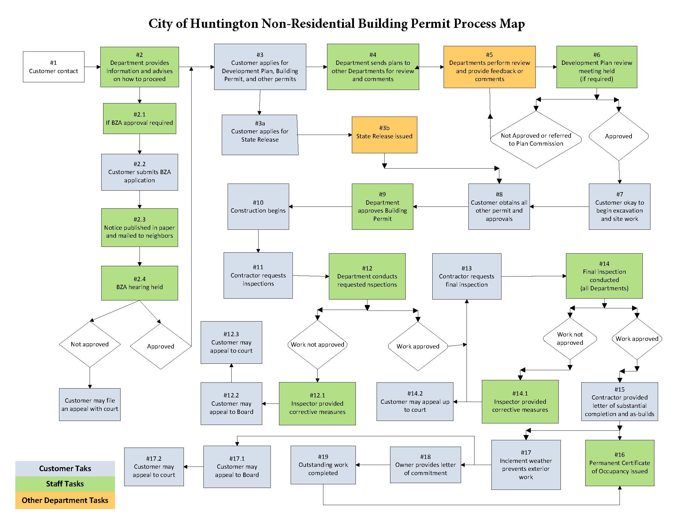
City Permit Process Map
As part of the City's participation in the Permitting Excellence Coalition through the Northeast Indiana Regional Partnership, permit process maps have been developed in order for applicants to better understand how permit applications are processed.
Non-Residential Building Permit Process Map:
Monthly PTSD Newsletter
Caregiver Support Program through VA
Building
Building Permit applications for properties under 3-acres in size:
- When a building permit application is submitted for any type of structure (shed, deck, pool, garage, pole barn, home, etc.) AND the property size is less than 3-acres, a primary and/or secondary On-site Sewage System (OSS) sites must be tested by a certified soil scientist and noted on a legal survey. The survey must show the size of the area and the distances to the closest property lines. Once the primary and/or secondary OSS sites have been provided on the survey, the normal review process will begin for the building permit application.
- The requirement to locate primary and/or secondary OSS sites before any building permits are issued (if under 3-acres) will prevent potential replacement sites from being damaged or eliminated since an OSS cannot be replaced in the same location as one that has failed. A new location on virgin, non-compacted soil is required for a replacement OSS. Please contact the Health Department at 260-358-4831 for questions pertaining to On-site Sewage Systems.
- Platted Subdivisions that have been approved through Plan Commission and recorded are exempt.
Pond Permit applications for properties of any size:
- When a pond permit application is submitted, primary and/or secondary On-site Sewage System (OSS) sites must be tested by a certified soil scientist and noted on a legal survey. The survey must show the size of the area and the distances to the closest property lines. Once the primary and/or secondary OSS sites have been provided on the survey, the normal review process will begin for the building permit application.
DCD oversees all building services for Huntington County (unincorporated areas only) and the towns of Andrews, Markle, Mount Etna, Roanoke, and Warren. Building services include:
- Issuing building, electrical, and plumbing permits
- Conducting building, electrical, and plumbing inspections
- Addressing unsafe building complaints
DCD's certified code professionals are here to serve you. Please feel free to contact us for information regarding construction standards and requirements or with general questions about our building or permit processes. If you aren't sure if your project will require a permit, please contact us, or review the list below.
What Requires a Permit?
Building Permits
- New homes (single-, two-, and multi-family)
- Manufactured & mobile homes (additional approval needed for single-wide)
- Commercial structures
- Interior renovations and additions to commercial structures
- Garages – attached or detached
- Pole barns, sheds, carports, pergolas
- Additions to existing homes, garages, pole barns, decks, porches, accessory structures
- Decks – attached or detached
- Porches – new, reconstruction of, or enclosing existing
- Swimming pools (in-ground and above-ground)
- Roof (Structural changes only - no permit needed for placement of new shingles. Maximum of 2 layers of shingles allowed on any roof)
Electrical Permits
- Upgrades
- New service
- Relocation of service
- Alteration to service
- Branch circuits
- Connection of service to a manufactured home or mobile home
Plumbing Permits
- New homes
- Additions
- Accessory structures with plumbing
- Additional plumbing in a structure
Other Permits
- Fence
- Sign
- Pond
- Floodplain development
Nonresidential projects may require a Construction Design Release from the Indiana Department of Homeland Security before DCD can issue a local permit. Please click here for more information on the state release process.
Planning & Zoning
DCD oversees all planning and zoning services for Huntington County (unincorporated areas only) and the towns of Andrews, Markle, Mount Etna, Roanoke, and Warren. We’re here to help you navigate the planning process and zoning regulations so you understand what types of development is permissible and what regulations may apply.
“Planning and zoning” services include, but are not limited to:
- Answering all zoning questions
- Maintaining and updating the Zoning Ordinance for each jurisdiction
- Variance requests (please check our Board of Zoning Appeals page for more information)
- Rezoning requests (please check our Plan Commission page for more information)
- Development plan requests (please check our Development Plan Committee page for more information)
- Subdivision requests (please check our Subdivision Plat Committee page for more information)
- Maintaining and updating the Comprehensive Plan for each jurisdiction
- Assigning new addresses
What is my Zoning District?
To determine the current zoning classification (or zoning district) of a property, please visit the Huntington County GIS site. Once you reach the GIS site, search for the property by address, owner, or parcel number (PIN). Make sure you’ve selected the correct parcel by reviewing the information on the “Parcel Report” tab. Then, to identify the zoning district, select the “Map” tab and turn on the County/Town Zoning layer (located under the “Planning” category). You may then use that classification to review the Zoning Ordinance requirements for that district. For your convenience, you may also view the Zoning Restrictions chart which outlines most of the zoning restrictions for each district.
When in doubt, please do not hesitate to contact DCD if you would like to learn about the zoning classification of a property.
Comprehensive Plans
Huntington County would like to thank all residents, community stakeholders, organizations and other participants who contributed their time and ideas throughout the planning process to complete the Huntington County Comprehensive Plan 2040.
Applications & Permits
All permits must be completed online through our permitting software. Payments can be made on the software as well.
Customers can use Geo Permitting to apply for the following projects. We will also be happy to assist you at our office.
- Commercial Structure - Please complete the Commercial Structure Permit.
- Concrete Porch and Porch Roof - Please complete the Deck/Porch/3-Season Room Permit.
- Electrical - Please complete the Mechanical Permit.
- Fence - Please complete the Fence/Sign Permit.
- Plumbing - Please complete the Mechanical Permit.
- Pond - Please complete the Swimming Pool/Pond Permit.
- Residential Accessory Structure - Please complete the Residential Structure Permit.
- Residential Dwelling Addition - Please complete the Residential Structure Permit.
- Residential Dwelling - Please complete the Residential Structure Permit.
- Residential Roof Alteration - Please complete the Residential Structure Permit.
- Sign - Please complete the Fence/Sign Permit.
- Swimming Pool - Please complete the Swimming Pool/Pond Permit.
- Wood Deck and Deck Roof - Please complete the Deck/Porch/3-Season Room Permit.
To apply, simply click here and create an online permitting account using your preferred email address. Then select "Huntington County, Indiana" from the list of jurisdictions and click "apply" next to the correct project type.
Customers are still welcome to file for all permits in the DCD office. Any staff member can assist with the online permit application process. Please contact DCD for questions or concerns about online permitting.
The following permits and land use/planning applications still require a paper application:
Permit Applications
Land Use & Planning Applications
- Development Plan Application
- Home Occupation Application
- Major Subdivision Application (Primary Plat)
- Major Subdivision Application (Secondary Plat)
- Minor Subdivision Application
- Rezoning Application
- Special Exception Application
- Variance from Development Standards Application
- Variance from Subdivision Code Application
- Variance of Use Application
Nonresidential projects may require a Construction Design Release from the Indiana Department of Homeland Security before DCD can issue a local permit. Please click here for more information on the state release process.
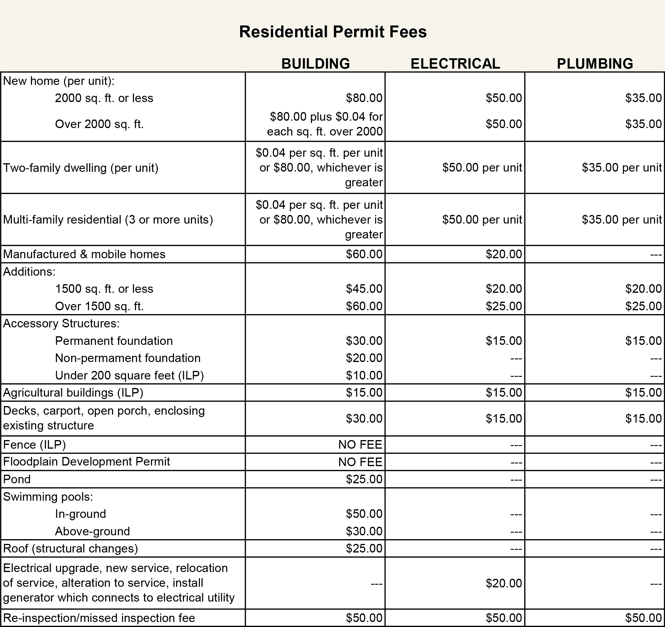
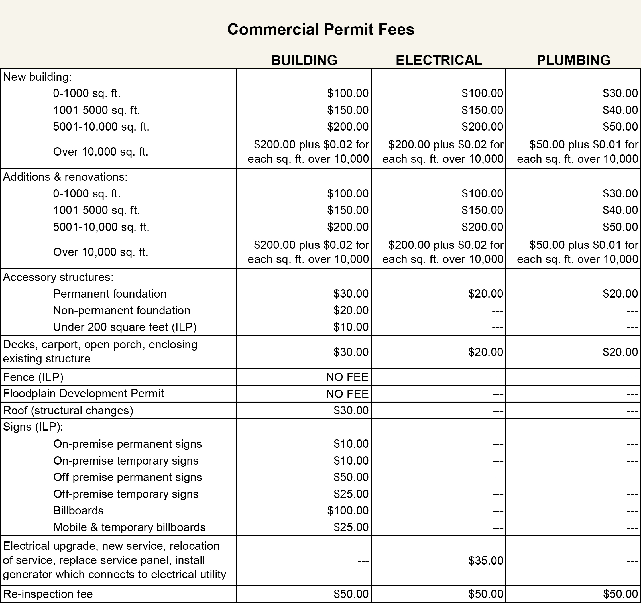
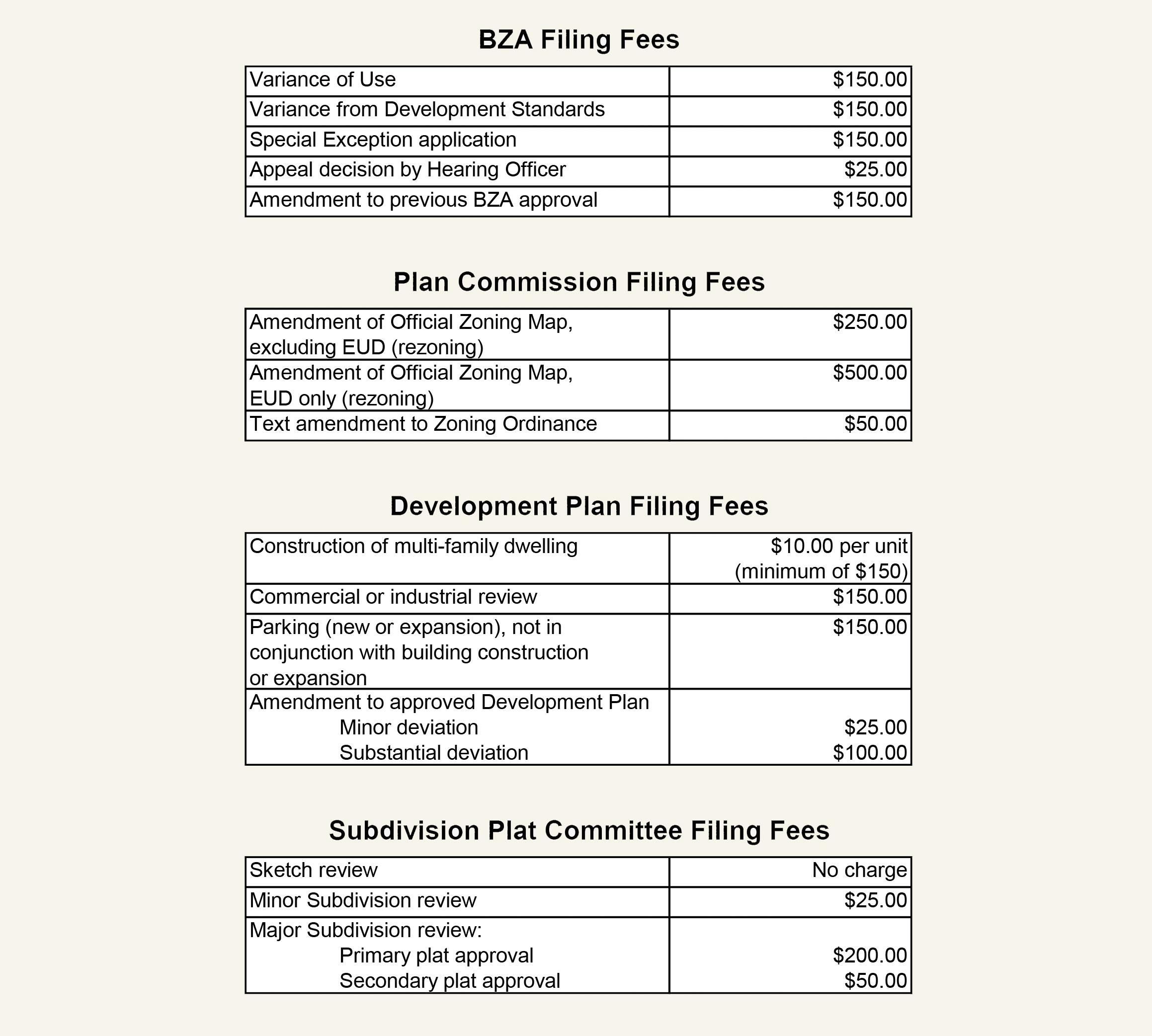
Fee Schedule
Listed below are the fees for permits and land use applications:
Codes & Ordinances
DCD follows these codes and ordinances when making building or planning decisions:
Please contact the office at (260) 358-4840 for questions or assistance.
Planning & Zoning
- Huntington County Zoning Ordinance
- Huntington County Subdivision Code
- Town of Andrews Zoning Code
- Town of Markle Zoning Code
- Town of Mt. Etna Zoning Code
- Town of Roanoke Zoning Code
- Town of Warren Zoning Code
Building & Unsafe
Permit Process Map
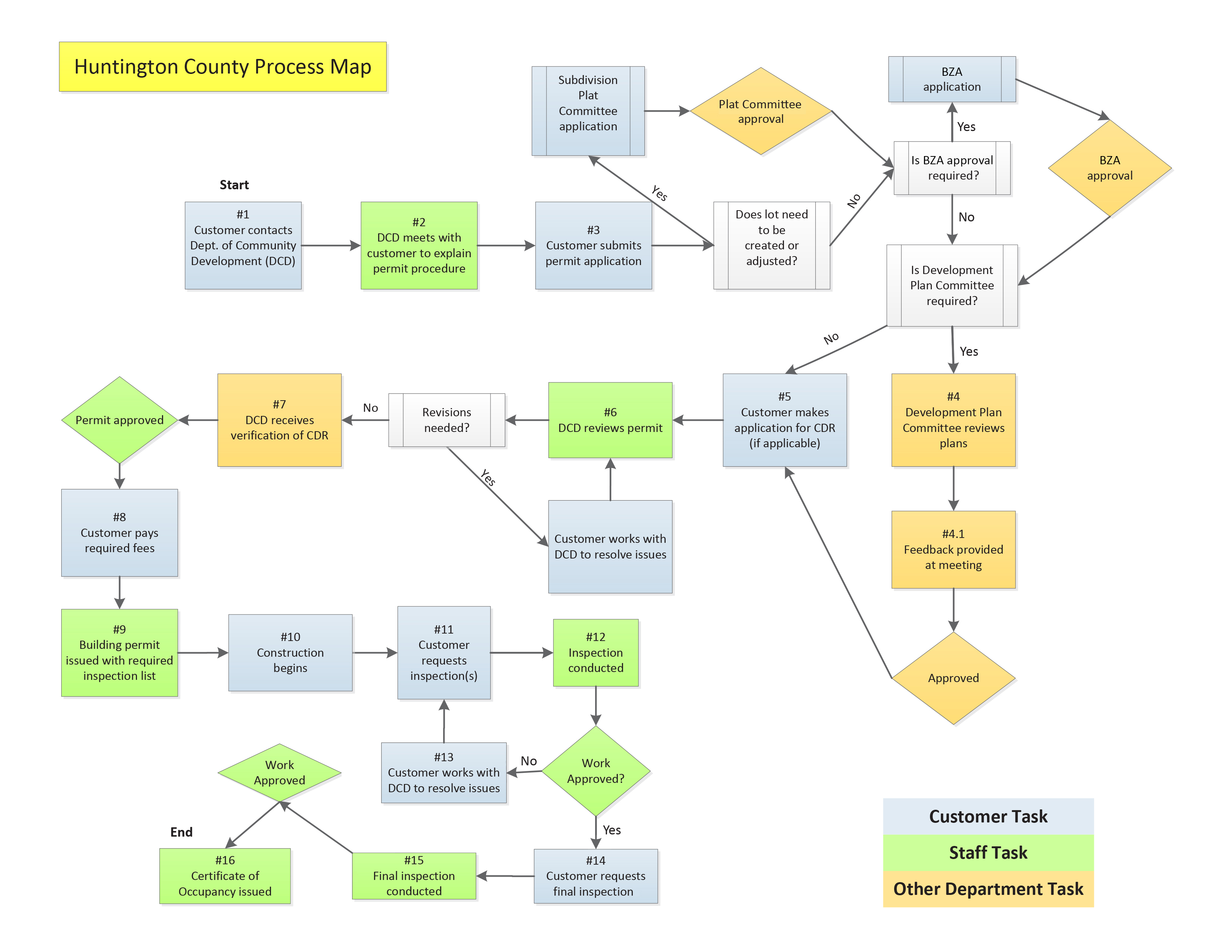
Huntington County is a participant in the Permitting Excellence Coalition through the Northeast Indiana Regional Partnership. All participating jurisdictions are creating "permit process maps" to help applicants better understand how permit applications are processed. DCD's permit process map is pictured below:
Floodplain Management
DCD (through the Executive Director) serves as Floodplain Administrator and enforces floodplain regulations in accordance with Section 917: Flood Hazard Area Overlay District (FHA) of the Zoning Ordinance for Huntington County and the towns of Andrews, Markle, Mount Etna, Roanoke, and Warren. Kim Hostetler is a Certified Floodplain Manager (CFM) by the Association of State Floodplain Managers (ASFPM).
| Am I in a Floodplain? |
Technically, everyone is located in a floodplain, but some areas are at higher risk than others. DCD regulates the higher-risk Special Flood Hazard Area (SFHA) lands subject to inundation by the regulatory flood, also known as the base flood or the 1 percent annual chance flood. To find out if your property is located within the SFHA, you can check the Flood Insurance Rate Maps (FIRMs) on file in our office. These maps are also available digitally on the Huntington County GIS site. Simply locate your property and turn on the layers “Flood Zones” and “Floodway.” If you need any mapping assistance or have any questions related to floodplains, we strongly encourage you to contact the Department.
| National Flood Insurance Program (NFIP) |
Huntington County and the towns of Andrews, Markle, Mount Etna, Roanoke, and Warren all participate in the National Flood Insurance Program (NFIP). Participation in the NFIP requires these jurisdictions to adopt a floodplain management ordinance to reduce future flood risks to new construction in the SFHA. In return, the federal government makes affordable flood insurance available to property owners as a financial protection against flood losses.
Most homeowners’ insurance policies will not cover losses due to flooding; flood insurance is only available through participation in the NFIP. For structures located within the SFHA, the purchase of flood insurance is mandatory if using a federally regulated/insured bank for a loan.
Click here for more information about flood insurance through the NFIP.
For more information on flood insurance, please click here (Flood Smart).
| Community Rating System (CRS) |
As of May 1, 2015, Huntington County and the towns of Andrews, Roanoke, and Warren are all participants in the NFIP’s Community Rating System (CRS), a voluntary incentive program that recognizes communities that implement floodplain management practices beyond federal minimum requirements. Huntington County, Andrews, Roanoke, and Warren are presently at a Class 7 rating, allowing flood insurance policyholders within these jurisdictions to receive an automatic 15% discount on flood insurance premiums.
| Floodplain Development Permit |
A floodplain development permit is required for nearly all construction or development activities within the SFHA. This includes activities such as excavation, filling, storage of materials, etc. Often, a floodplain development permit will be required in conjunction with a building permit. However, even if a building permit is not required for the project, a floodplain development permit may still be required. Please contact the Department before proceeding with any development activities within the floodplain for project-specific regulations and to obtain all required permits.
As part of your floodplain development permit application, you will need to determine the Base Flood Elevation (BFE) for your property. One way to do so is to use the Indiana Floodplain Information Portal (INFIP), an online resource provided by the Indiana Department of Natural Resources (DNR). Once you’ve located your property on the portal, follow the instructions to request an electronic Floodplain Analysis and Regulatory Assessment, or eFARA. If you need assistance with requesting an eFARA, please do not hesitate to contact the Department.
Please note: If your proposed project is located within the floodway portion of the SFHA, you will also need to obtain a permit for construction within the floodway from DNR’s Division of Water before a local floodplain development permit can be issued.
| Click here to visit the FEMA.gov homepage |
Unsafe Buildings
Under the authority of IC 36-7-9, Huntington County and the towns of Andrews, Markle, Mount Etna, Roanoke, and Warren have enacted an unsafe building ordinance. DCD is responsible for the administration and enforcement of unsafe structures. The unsafe building law is a tool used by these jurisdictions to maintain safe building conditions, eliminate blight, and preserve property values.
The town of Andrews has adopted additional criteria concerning standards for building condition or maintenance in the form of a minimum housing code, which is jointly enforced by DCD and the Health Department.
What is an Unsafe Building?
IC 36-7-9-4 defines an “unsafe building” as any building or structure, or any part of a building or structure, that is:
- In an impaired structural condition that makes it unsafe to a person or property.
- A fire hazard.
- A hazard to the public health.
- A public nuisance.
- Dangerous to a person or property because of a violation of a statute or ordinance concerning building condition or maintenance.
- Vacant and not maintained in a manner that would allow human habitation, occupancy, or use under the requirements of a statute or an ordinance.
Unsafe Process
The Department investigates complaints filed by the general public concerning unsafe structures, conducts inspections, and issues orders of enforcement. For properties in the unincorporated areas of the county, the Huntington County Board of Commissioners is the designated hearing authority. For properties within an incorporated town, the corresponding town council serves as the designated hearing authority.
When the Department issues an order of enforcement, and that order is upheld or modified by the hearing authority, property owners are given time to correct the deficiencies as outlined in the order. Under state law, the maximum timeframe for compliance that the Department is allowed to give is sixty (60) days, if the order is upheld by the hearing authority. The hearing authority may also modify the order to give additional time beyond the sixty (60) day limit. If a property owner fails to make necessary repairs in a timely fashion, the hearing authority may assess penalties for non-compliance, arrange for repairs, or even demolish the structure at the expense of the owner.
To submit an unsafe structure complaint, please complete this form.
Board of Commissioners' Appointments
Below is a list of volunteer boards that serve various activities within Huntington County. The members listed are appointments made by the County Commissioners and/or County Council. The listing also includes the term expiration date.
All positions that have an expiring term are open for anyone who meets the specified criteria. Advertising for interested volunteers is usually posted in October or November, for appointments starting the first of the new year.
|
Board of Electrical Examiners – 1 Year Terms |
|
|
One member must be a licensed electrical contractor and one must be a citizen of Huntington County. |
|
|
Paul Asperger |
Term Expires: 12/31/22 |
|
Tim Young |
Term Expires: 12/31/22 |
|
PTABOA – 1 Year Terms (Party can be waived) 3 member board, 2 appointed by Commissioners/1 appointed by Council |
||
|
Les Howe |
Commissioner Appointed |
Term Expires: 12/31/22 |
|
Dominick Posillipo |
Commissioner Appointed |
|
|
Barry Christen |
Council Appointed |
Term Expires: 12/31/20 |
|
Huntington County Tourism Commission – 2 Year Terms |
|
|
Eric Harris |
Term Expires: 12/31/21 |
|
LeAnn Buzzard |
Term Expires: 12/31/23 |
|
Terry L. Miller, II |
Term Expires: 12/31/23 |
|
Kyle Jones |
Term Expires: 12/31/23 |
|
Vacant |
|
|
Dawn Lakes Regional Sewer District – 3 Year Terms Must live in the district. |
|
|
Robert Schlicht |
Term Expires: 12/31/21 |
|
Jill Cutshall |
Term Expires: 12/31/21 |
|
Mike Stobb |
Term Expires: 12/31/19 |
|
Norwood Regional Water & Sewer District – 3 Year Terms |
||
|
3 members – one appointed by County Commissioner, one by County Council, one by Town of Andrews Must live in the district. |
||
|
Jeff Shoup |
Commissioner Appointed |
Term Expires: 12/31/22 |
|
Timothy D. Jones |
Council Appointed |
Term Expires: 12/31/21 |
|
Gary Rice (?) |
Andrews Appointed |
Term Expires: 12/31/19 |
|
Rural Huntington Regional Water & Sewer District – 4 Year Terms Must live in the district. |
|
|
5 Members – all appointed by the Commissioners. 2 Additional members when regionalization with the City of Huntington begins, one from County Council and one from Mayor. |
|
|
Bruce Stanton |
Term Expires: 12/31/22 |
|
Alan Pflieger |
Term Expires: 12/31/22 |
|
Not filed |
Term Expires: 12/31/ |
|
James Scheiber |
Term Expires: 12/31/21 |
|
Paul Hirschy |
Term Expires: 10/19/21 |
|
Huntington City/Township Public Library – 4 Year Terms |
||
|
Must have lived in library district for 2 years. All are Joint Appointments with Wells County. |
||
|
Theresa Salzano |
Term Expires: 12/31/23 |
|
|
Jessica Mankey |
Commissioner appointed |
Term Expires: 12/31/25 |
|
Jamie Hoffman |
Council appointed |
Term Expires: 12/31/22 |
|
Andrews Public Library – 4 Year Terms |
||
|
Must Live in Andrews or Dallas Township. |
||
|
Karla Saalfrank-Manes |
Commissioner appointed |
Term Expires: 06/30/25 |
|
Melanie Park |
Council appointed |
Term Expires: 06/30/21 |
|
Roanoke Public Library – 4 Year Terms |
||
|
Must live in Roanoke or Jackson Township |
||
|
Ryan Sexton |
Commissioner appointed |
Term Expires: 12/31/25 |
|
Barbara Carter |
Council appointed |
Term Expires: 12/31/24 |
|
Salamonie - Warren Library – 4 Year Terms |
|
|
Must live in Salamonie Township or Warren |
|
|
Kandace Villaneuva |
Term Expires: 09/30/22 |
|
Hallie 'Kate' Zoerb |
Term Expires: 09/30/24 |
|
Drainage Board – 3 Year Terms |
|
|
1 Member is a Commissioner: Tom Wall |
|
|
Matt Gilbert (Polk, Lancaster, Rock Creek Townships) |
Term Expires: 12/31/24 |
|
Jim Michel (Warren, Clear Creek, Jackson Townships) |
Term Expires: 12/31/24 |
|
Terry Keiffer (Wayne, Jefferson, Salamonie Townships) |
Term Expires: 12/31/22 |
|
Bob Gressley (Dallas, Huntington, Union Townships) |
Term Expires: 12/31/24 |
|
Solid Waste Management Board |
|
|
|
|
Tom Wall |
|
|
Rob Miller |
|
|
Terry Stoffel |
|
|
Member: |
John Stoeckley (Town of Roanoke) |
|
Huntington County Planning Commission – 4 Year Terms |
|
|
|
|
Commissioner: |
Terry Stoffel |
|
Council: |
Terry Miller |
|
Surveyor: |
Jay Poe |
|
Extension Office: |
Ed Farris |
|
Jason Meier |
Term Expires: 01/01/26 |
|
Steve Park |
Term Expires: 01/01/23 |
|
James Sprowl |
Term Expires: 01/01/23 |
|
Denise Kreider |
Term Expires: 01/01/25 |
|
Todd Landrum |
Term Expires: 01/01/26 |
|
County BZA – 4 Year Terms |
||
|
||
|
Kevin Deakyne |
Council appointed |
Term Expires: 01/01/24 |
|
Steve Park |
Plan Commission appointed |
Term Expires: 01/01/22 |
|
Nick Caley |
Commissioners' appointed |
Term Expires: 01/01/24 |
|
Dale Hawkins |
Commissioners' appointed |
Term Expires: 01/01/23 |
|
James Sprowl |
Plan Commission appointed |
Term Expires: 01/01/21 |
|
Town Plan Commission – 4 Year Terms
|
|
|
Roanoke – Brandon Kitt |
Term Expires: 1/2/21 |
|
Roanoke – Joe Cassidy |
Term Expires: 1/4/24 |
|
Andrews – Carl Turner |
Term Expires: 1/2/21 |
|
Andrews – Andy Eckert |
Term Expires: 1/4/24 |
|
Warren – Jeffrey Souder |
Term Expires: 1/4/25 |
|
Warren – (Not filled) |
Term Expires: 01/01/2022 |
|
Tax Abatement Review Committee – 3 Year Terms |
|
|
|
|
Council Representative |
|
|
Commissioners Representative |
Rob Miller |
|
Commissioner/Council Joint |
|
|
County Council Appointment |
|
|
Commissioner Appointed |
|
|
Wabash River Heritage Commission – 2 Year Terms |
|
|
Dave Hacker |
Term Expires: 12/31/21 |
|
Alternate – Donald Mathias |
Term Expires: 12/31/21 |
|
Community & Family Services – 4 Year Terms |
|
|
|
|
Bre Sullivan |
Term Expires: 12/31/25 |
|
Huntington County Health Board – 4 Year Terms |
|
|
|
|
Paul Roth (R) |
Term Expires: 12/31/22 |
|
Dr. Matt Pflieger (R) |
Term Expires: 12/31/22 |
|
Monte Davis (D) |
Term Expires: 12/31/22 |
|
Dr. Janelle Pfleiger (D) |
Term Expires: 12/31/23 |
|
Terry Daniels (R) |
Term Expires: 12/31/23 |
|
Megan Friesen (D) |
Term Expires: 12/31/24 |
|
Robin Baker (R) |
Term Expires: 12/31/21 |
|
County’s Common Construction Wage Committee – No Term Specified |
|
|
Rob Miller |
|
Jim Dinius |
|
Keith Eller |
|
Alcohol Beverage Board – 1 Year Term |
||
|
||
|
Carrie Miller |
Commissioners appointed |
Term Expires: 12/31/22 |
|
Doyle Krieg |
Council appointed |
Term Expires: 12/31/19 |
|
Huntington County Community Corrections – 4 Year Terms |
|
|
|
|
Discretionary Appointments: |
|
|
Minority - Not filed |
Term Expires: 2024 |
|
J. Ryan Wall |
Term Expires: 2024 |
|
Sharon Metzger |
Term Expires: 2024 |
|
Tom Wall, Commissioner |
Term Expires: 2024 |
|
Don Shone, former offender |
Term Expires: 2024 |
|
Ordinance Required Appointments: |
|
|
Sheriff: Chris Newton |
Term Expires: 2024 |
|
Prosecutor: Amy Richison |
Term Expires: 2022 |
|
DCF Director: Kerri Baker |
Term Expires: 2024 |
|
Mayor: Richard Strick |
Term Expires: 2024 |
|
Circuit Court Judge: Davin Smith |
Term Expires: 2024 |
|
Superior Court Judge: Jennifer Newton |
Term Expires: 2026 |
|
Defense Attorney: Mark Wiley |
Term Expires: 2024 |
|
County Council member: |
Term Expires: 2024 |
|
Probation Officer: Heather Malone |
Term Expires: 2024 |
|
Juvenile Probation Officer: Brooke Trice |
Term Expires: 2024 |
|
School Superintendent: Chad Daugherty |
Term Expires: 2024 |
|
Victim Advocate: Wendy Ash |
Term Expires: 2024 |
|
Bowen Center Administrator: Shelly Snyder |
Term Expires: 2024 |
Representing Yourself in Court
Child Support Information
Memorial Bench Donation Program
Memorialize a bench within your community! This is a great way to support your local recreational system while memorializing or honoring a loved one. These can be used to mark important occasions including graduations, weddings, anniversaries, births or the passing of a friend or family member.
A one-time tax deductible gift of $500 made payable to the City of Huntington-Park Donation Fund will go to purchase a bench, engrave a plaque and install it within our community in parks, along trails and in public spaces. The City of Huntington has the right to review the inscription and in its sole discretion reject any that are found to be objectionable or offensive given the public setting.
Download this form and return it, along with your donation, to the Parks and Recreation office located at 634 Webster St.
The form may also be submitted online by clicking here.
Useful Links
- Downtown Master Plan Final Draft - Council Presentation (video)
- Visit the Downtown Master Plan Website
- Downtown Master Plan Final Draft
- Downtown Master Plan Final Draft - Council Presentation
- Downtown Master Plan Final Draft - Council Project Summary Handout
- 2024 Budgeted Spending
- 2023 Receipts & Disbursements
- Water Quality Report - April 2024
- Huntington Recovery Meetings Schedule
Services
- Financial Assistance for Nursing Home or Assisted Living Care
- Apply for a Special Event Permit Involving a Street Closure
- Apply for VA Health Care
- Ask the Mayor to Issue a Proclamation for a Cause I Support
- City Ordinances
- County Action Center
- Court-Approved Batterers Intervention Program
- Court-Approved Drug & Alcohol Programs
- Driving Privileges Restoration Clinic
Upcoming Events
- City of Huntington Plan Commission04/25/246:30 pm - End
- Arbor Day Celebration & Volunteer Event04/27/248:30 am - 1:00 pm
- Special Meeting of the Huntington County Commissioners04/29/245:00 pm - End
Contact Us
Contact Us
Huntington, IN 46750
Contact Us
- Phone: (260) 356-1400 x 2000
- Fax:
(260) 358-2338 - Staff Directory
- Hours: 8 a.m. to 4:30 p.m.
Monday through Friday
Contact Us
- Phone: (260) 356-1400 x 2019
- Fax:
(260) 358-2338 - Staff Directory
- Hours: 8 a.m. to 4:30 p.m.
Monday through Friday
Contact Us
City Clerk Treasurer
- Phone: (260) 356-1400 x 2019
- Fax:
(260) 358-2332 - Staff Directory
- Hours: 8 a.m. to 4:30 p.m.
Monday through Friday
Contact Us
Manager
Contact Us
- Phone: (260) 358-4814
- Fax:
(260) 358-4813 - Staff Directory
- Hours: 8 a.m. to Noon
1 to 4:30 p.m.
Monday through Friday
Contact Us
City Services Superintendent
- Phone: (260) 356-4720
- Fax:
(260) 358-2324 - Staff Directory
- Hours: 7 a.m. to 3 p.m.
Monday through Friday
Contact Us
County Assessor
- Phone: (260) 358-4800
- Fax:
(260) 355-2315 - Staff Directory
- Hours: 8 a.m. to 4:30 p.m.
Monday through Friday
Closed all Major Holidays
Contact Us
Auditor
Huntington, IN 46750
- Phone: (260) 358-4804
- Fax:
(260) 358-4823 - Staff Directory
- Hours: 8 a.m. to 4:30 p.m.
Monday through Friday
Contact Us
Clerk
- Phone: (260) 358-4817
- Fax:
(260) 358-4880 - Staff Directory
- Hours: 8 a.m. to 4:30 p.m.
Monday through Friday
Contact Us
Clerk
Huntington, IN 46750
- Phone: (260) 358-4820
- Fax:
(260) 358-4880 - Staff Directory
- Hours: 8 a.m. to 4:30 p.m.
Monday through Friday
Contact Us
Office Manager
Huntington, IN 46750
- Phone: (260) 358-4822
- Fax:
(260) 358-4823 - Staff Directory
- Hours: Monday through Friday
8 a.m. to 4:30 p.m.
Commissioners' Meetings are every other Monday starting at 8:30 a.m. unless otherwise noted.
Contact Us
Coroner
Huntington, IN 46750
- Phone: (260) 356-4488
- Staff Directory
- Hours: 8 a.m. to 4:30 p.m.
Monday through Friday
Contact Us
- Phone: (260) 358-4840
- Fax:
(260) 355-2313 - Staff Directory
- Hours: 8 a.m. to 4:30 p.m.
Monday through Friday
Contact Us
Director of Community Development & Redevelopment
- Phone: (260) 356-5146
- Fax:
(260) 454-5211 - Staff Directory
- Hours: 8 a.m. to 4:30 p.m.
*Closed Noon to 1 p.m.*
Monday through Friday
Contact Us
HR Director & ADA Coordinator
- Phone: (260) 355-2329
- Fax:
(260) 359-3638 - Staff Directory
- Hours: 8 a.m. to 4:30 p.m.
Monday through Friday
Contact Us
Huntington, IN 46750
- Phone: (260) 358-4831
- Fax:
(260) 358-4899 - Staff Directory
- Hours: 8 a.m. to 4:30 p.m.
Monday through Friday
Closed daily for lunch 11:45 a.m. to 12:45 p.m.
*To report a public health or environmental emergency after business hours, please call 911.*
Contact Us
Huntington, IN 46750
- Phone: (260) 358-4870
- Fax:
(260) 358-4871 - Staff Directory
- Hours: 8 a.m. to 4:30 p.m.
Monday through Friday
Contact Us
Director of Public Works and Engineering Services
- Phone: (260) 356-1400 x 2021
- Fax:
(260) 356-0344 - Staff Directory
- Hours: 8 a.m. to 4:30 p.m.
Monday through Friday
Contact Us

Fire Chief
Huntington, IN 46750
- Phone: (260) 356-3620
- Staff Directory
- Hours: Emergency - Call 911
Administrative Office:
7 a.m. to 3 p.m.
Monday through Friday
Contact Us
GIS / IT Technician
Huntington, IN 46750
- Phone: (260) 358-4895
- Staff Directory
- Hours: Monday-Friday 8am-4:30pm
Contact Us
Superintendent
Huntington, IN 46750
- Phone: (260) 358-4881
- Fax:
(260) 358-4882 - Staff Directory
- Hours: 7 a.m. to 3 p.m.
Monday through Friday
Contact Us
Human Resources
- Phone: (260) 356-1400 x 2602
- Fax:
(260) 358-2330 - Staff Directory
- Hours: 8 a.m. to 4:30 p.m.
Monday through Friday
Contact Us
Huntington, IN 46750
- Phone: (260) 356-1400 x 2000
- Fax:
(260) 358-2338 - Staff Directory
- Hours: City Building: 8 a.m. to 4:30 p.m. Monday - Friday
City Services: 7 a.m. to 3 p.m. Monday - Friday
Contact Us
Chief of Police
- Phone: (260) 358-2308
- Fax:
(260) 358-2343 - Staff Directory
- Hours: Administrative Offices & Records Division:
8 a.m. to 4 p.m.
Monday through Friday
Emergency - Call 911
Contact Us
Jail Commander
Huntington, IN 46750
- Phone: (260) 356-3110
- Fax:
(260) 358-4877 - Staff Directory
- Hours: Jail operates 24 hours a day / 7 days a week
Contact Us
Foreman
Huntington, IN 46750
- Phone: (260) 356-0432
- Staff Directory
- Hours: 7 a.m. to 3 p.m.
Monday through Friday
Contact Us
Superintendent of Parks and Recreation
- Phone: (260) 358-2323
- Fax:
(260) 358-2324 - Staff Directory
- Hours: 7 a.m. to 3 p.m.
Monday through Friday
Contact Us
Chief Probation Officer
- Phone: (260) 358-4841
- Fax:
(260) 358-4853 - Staff Directory
- Hours: 8 a.m. to 12 p.m.
1p.m. to 4:30 p.m.
Monday through Friday
Contact Us
- Phone: (260) 358-4846
- Assistant: (260) 358-4884
- Fax:
(260) 358-2671 - Staff Directory
- Hours: 8 a.m. to 4:30 p.m.
Monday through Friday
Contact Us
County Recorder
Huntington, IN 46750
- Phone: (260) 358-4848
- Staff Directory
- Hours: 8 a.m. to 4:30 p.m.
Monday through Friday
Contact Us
Huntington, IN 46750
- Phone: (260) 356-2520
- Fax:
(260) 358-4877 - Staff Directory
- Hours: 8 a.m. to 4:30 p.m.
Monday through Friday
Contact Us
Director
Huntington, IN 46750
- Phone: (260) 358-4886
- Staff Directory
- Hours: Wednesday: 7 a.m. to 3 p.m.
Thursdays by Appointment
First and Third Saturdays of the Month: 8 to 11:30 a.m.
Contact Us
- Phone: (260) 358-4852
- Fax:
(260) 359-4415 - Staff Directory
- Hours: 8:30 a.m. to Noon
1 to 4:30 p.m.
Monday through Friday
Contact Us
County Surveyor
Huntington, IN 46750
- Phone: (260) 358-4856
- Staff Directory
- Hours: 8 a.m. to 4:30 p.m.
Monday through Friday
Contact Us
Treasurer
- Phone: (260) 358-4860
- Staff Directory
- Hours: 8 a.m. to 4:30 p.m.
Monday through Friday
Contact Us
Director
Huntington, IN 46750
- Phone: (260) 358-4863
- Fax:
(260) 359-4400 - Staff Directory
- Hours: 8 a.m. to 4:30 p.m.
Monday through Friday
*Closed Daily for Lunch from Noon to 1 p.m.*
Contact Us
Huntington, IN 46750
- Phone: (260) 358-2313
- Fax:
(260) 358-2317 - Staff Directory
- Hours: F & V Operations & Resources, Management for WPC
Contact Us
Utilities Billing - Office Manager
Water Billing Office: 300 Cherry St.
Huntington, IN 46750
- Phone: (260) 356-3220
- Staff Directory
- Hours: Operations & Distribution
7 a.m. to 3 p.m.
Monday through Friday
Phone: (260) 358-2309
For emergencies regarding your utility service on weekends and holidays, or before 7 a.m./after 3 p.m. on weekdays, please call (260) 227-1513.
Water Billing Office
8 a.m. to 4:30 p.m.
Monday through Friday
Phone: (260) 356-3220
Fax: (260) 356-0344
Contact Us
Contact Us
Huntington, IN 46750
- Phone: (260) 358-4800
- Fax:
(260) 355-2315 - Staff Directory
Contact Us
Contact Us
- Phone: (260) 358-4836
- Fax:
(260) 355-2313 - Staff Directory
- Hours: 8 a.m. to 4:30 p.m.
Monday through Friday
Contact Us
Executive Director
- Phone: (260) 358-4840
- Fax:
(260) 355-2313 - Staff Directory
- Hours: 8 a.m. to 4:30 p.m.
Monday through Friday
Contact Us
Executive Director
- Phone: (260) 358-4840
- Fax:
(260) 355-2313 - Staff Directory
- Hours: 8 a.m. to 4:30 p.m.
Monday through Friday
Contact Us
Executive Director
- Fax:
(260) 355-2313 - Phone: (260) 358-4840
- Staff Directory
- Hours: 8 a.m. to 4:30 p.m.
Monday through Friday
Contact Us
Director of Community Development & Redevelopment
- Phone: (260) 356-5146
- Fax:
(260) 454-5211 - Staff Directory
- Hours: 8 a.m. to 4:30 p.m.
*Closed Noon to 1 p.m.*
Monday through Friday
Contact Us
Director of Community Development & Redevelopment
- Phone: (260) 356-5146
- Fax:
(260) 454-5211 - Staff Directory
- Hours: 8 a.m. to 4:30 p.m.
*Closed Noon to 1 p.m.*
Monday through Friday
Contact Us
Director of Community Development & Redevelopment
- Phone: (260) 356-5146
- Fax:
(260) 454-5211 - Staff Directory
- Hours: 8 a.m. to 4:30 p.m.
*Closed Noon to 1 p.m.*
Monday through Friday
Contact Us
Director of Community Development & Redevelopment
- Phone: (260) 356-5146
- Fax:
(260) 454-5211 - Staff Directory
- Hours: 8 a.m. to 4:30 p.m.
*Closed Noon to 1 p.m.*
Monday through Friday
Contact Us
Director of Community Development & Redevelopment
- Phone: (260) 356-5146
- Fax:
(260) 454-5211 - Staff Directory
- Hours: 8 a.m. to 4:30 p.m.
*Closed Noon to 1 p.m.*
Monday through Friday
Contact Us
Director of Community Development & Redevelopment
- Phone: (260) 356-5146
- Fax:
(260) 454-5211 - Staff Directory
- Hours: 8 a.m. to 4:30 p.m.
*Closed Noon to 1 p.m.*
Monday through Friday
Contact Us
EMA Director
Huntington, IN 46750
- Phone: (260) 358-4870
- Fax:
(260) 358-4871 - Staff Directory
- Hours: 8 a.m. to 4:30 p.m.
Monday through Friday
Contact Us
EMA Director
Huntington, IN 46750
- Phone: (260) 358-4870
- Fax:
(260) 358-4871 - Staff Directory
- Hours: 8 a.m. to 4:30 p.m.
Monday through Friday
Contact Us
Chief of Police
- Phone: (260) 358-2308
- Fax:
(260) 358-2343 - Staff Directory
- Hours: Administrative Offices & Records Division:
8 a.m. to 4 p.m.
Monday through Friday
Emergency - Call 911
Contact Us
Contact Us
Chief of Police
- Phone: (260) 358-2308
- Fax:
(260) 358-2343 - Staff Directory
- Hours: Administrative Offices & Records Division:
8 a.m. to 4 p.m.
Monday through Friday
Emergency - Call 911
Contact Us
Office Manager
- Phone: (260) 358-2308
- Fax:
(260) 358-2343 - Staff Directory
- Hours: Administrative Offices & Records Division:
8 a.m. to 4 p.m.
Monday through Friday
Emergency - Call 911
Contact Us
- Phone: (260) 356-7110
- Staff Directory
- Hours: Administrative Offices & Records Division:
8 a.m. to 4 p.m.
Monday through Friday
Emergency - Call 911
Contact Us
Officer
Contact Us
Superintendent of Parks and Recreation
Huntington, IN 46750
- Home: (260) 356-4720
- Home Fax:
(260) 358-2324 - Staff Directory
Contact Us
Huntington, IN 46750
- Phone: (260) 358-4841
- Fax:
(260) 358-4853 - Staff Directory
- Hours: 8 a.m. to Noon
1 to 4:30 p.m.
Monday through Friday
Contact Us
- Phone: (260) 358-4841
- Fax:
(260) 358-4853 - Staff Directory
Contact Us
Drug Court Coordinator and Assistant Chief Probation Officer
- Phone: (260) 358-4841
- Fax:
(260) 358-4853 - Staff Directory
- Hours: 8 a.m. to 4:30 p.m.
Monday through Friday
Contact Us
Electronic Monitoring and Misdemeanor Probation Officer
- Phone: (260) 358-4841
- Fax:
(260) 358-4853 - Staff Directory
- Hours: 8 a.m. to 4:30 p.m.
Monday through Friday
Contact Us
- Phone: (260) 358-4846
- Staff Directory
- Hours: 8 a.m. to 4:30 p.m.
Monday through Friday
Contact Us
- Phone: (260) 358-4884
- Staff Directory
- Hours: 8 a.m. to 4:30 p.m.
Monday through Friday
Contact Us
County Surveyor
- Phone: (260) 358-4856
- Staff Directory
- Hours: 8 a.m. to 4:30 p.m.
Monday through Friday
Contact Us
City Services Superintendent
- Phone: (260) 356-4720
- Staff Directory
- Hours: 7 a.m. to 3 p.m.
Monday through Friday
Contact Us
City Clerk Treasurer
- Phone: (260) 356-1400 x 2019
- Staff Directory
- Hours: 8 a.m. to 4:30 p.m.
Monday through Friday
Contact Us
Director of Public Works and Engineering Services
Huntington, IN 46750
- Phone: (260) 356-1400 x 2021
- Fax:
(260) 356-0344 - Staff Directory
- Hours: 8 a.m. to 4:30 p.m.
Monday through Friday
Contact Us
County Assessor
- Fax:
(260) 355-2315 - Phone: (260) 358-4800
- Staff Directory
- Hours: 8 a.m. to 4:30 p.m.
Monday through Friday
Contact Us
Huntington, IN 46750
- Phone: (260) 359-3640
- Fax:
(260) 359-3641 - Staff Directory
Contact Us
Public Safety Dispatch Director
- Phone: (260) 356-8316
- Phone 2: (260) 356-7110
- Fax:
(260) 358-2670 - Staff Directory
- Hours: 24 hours 7 days a week
Contact Us
Public Safety Dispatch Director
- Phone: (260) 356-8316
- Phone 2: (260) 356-7110
- Staff Directory
- Hours: 24 hours 7 days a week
Contact Us
Community Engagement Volunteer Coordinator
- Phone: (260) 356-1400 x 2003
- Staff Directory
- Hours: 7 a.m. to 3 p.m.
Monday through Friday
Contact Us
Superintendent of Parks and Recreation
- Phone: (260) 356-4720
- Staff Directory
- Hours: 7 a.m. to 3 p.m.
Monday through Friday
Contact Us
Huntington, IN 46750
- Phone: (260) 356-1400 x 2022
- Staff Directory
- Hours: 8 a.m. to 4:30 p.m.
Monday through Friday
Contact Us
HR Director & ADA Coordinator
Huntington, IN 46750
- Phone: (260) 355-2329
- Staff Directory
- Hours: 8 a.m. - 4:30 p.m.
Monday through Friday
Contact Us
- Staff Directory
- Hours: Hours: 8:00 AM to 4:30 PM - Contact #260-356-1400, ext. 2802
Contact Us
Communications Coordinator
- Phone: (260) 356-1400 x 2026
- Staff Directory
- Hours: 8 a.m. to 4:30 p.m.
Monday through Friday
Contact Us
- Phone: (260) 356-1400 x 2019
- Staff Directory
- Hours: 8 a.m. to 4:30 p.m.
Monday through Friday
Contact Us
Director
- Phone: (260) 359-3640
- Fax:
(260) 359-3641 - Staff Directory
- Hours: 8 a.m. to 4:30 p.m.
Monday through Friday
Contact Us
- Phone: (260) 356-1400 x 2019
- Staff Directory
- Hours: 8 a.m. to 4:30 p.m.
Monday through Friday
Contact Us
City Clerk Treasurer
- Phone: (260) 356-1400 x 2019
- Staff Directory
- Hours: 8 a.m. to 4:30 p.m.
Monday through Friday
Contact Us
Human Resources
- Phone: (260) 356-1400 x 2004
- Fax:
(260) 358-2330 - Staff Directory
- Hours: 8 a.m. to 4:30 p.m.
Monday through Friday
Contact Us
Clerk
- Phone: (260) 358-4820
- Fax:
(260) 358-4880 - Staff Directory
- Hours: 8 a.m. to 4:30 p.m.
Monday through Friday
Contact Us
Clerk
- Phone: (260) 358-4817
- Fax:
(260) 358-4880 - Staff Directory
- Hours: 8 a.m. to 4:30 p.m.
Monday through Friday
Contact Us
- Phone: (260) 356-1400
- Staff Directory
- Hours: 8 a.m. to 4:30 p.m.
Monday through Friday
Contact Us
Director of Community Development & Redevelopment
- Phone: (260) 356-5146 x 2021
- Staff Directory
- Hours: 8 a.m. to 4:30 p.m.
Monday through Friday
Contact Us
Director of Community Development & Redevelopment
- Phone: (260) 356-4720
- Staff Directory
- Hours: 8 a.m. to 4:30 p.m.
Monday through Friday